-
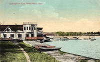
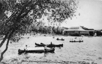
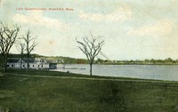
 At Lake Quannapowitt, Wakefield, Mass.
 Postcard shows a view of the eastern shore of Lake Quannapowitt.
-
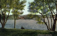
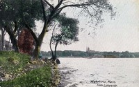 Wakefield, Mass. from lakeside
 Postcard shows a view looking south from the eastern shore of Lake Quannapowitt. The boat house and the towers of the Baptist and Congregational churches are visible in the distance.
-
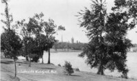 Lakeside, Wakefield, Mass.
 Postcard shows a view looking southwest from the eastern shore of Lake Quannapowitt. The towers of the Baptist and Congregational churches are visible in the distance.
-
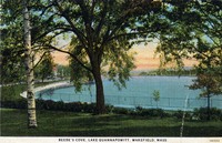 Beebe's Cove,Lake Quannapowitt, Wakefield, Mass.
 Postcard shows a view looking south towards the Common from Beebe Cove on the east shore of Lake Quannapowitt.
-
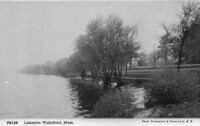 Lakeside, Wakefield, Mass.
 Postcard shows a view of the eastern shore of Lake Quannapowitt.
-
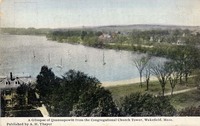
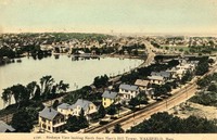
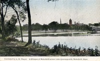 A glimpse of Wakefield across Lake Quannapowitt, Wakefield, Mass.
 Postcard shows a view looking southwest from Main Street across the Common toward the boathouse at the end of Lake Street on the southern shore of Lake Quannapowitt. The spires of the Congregational and Baptist churches are visible.
-
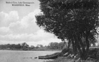 Beebe's Cove, Lake Quannapowitt, Wakefield, Mass.
 Postcard shows a view of Beebe Cove on the east shore of Lake Quannapowitt.
-
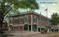 Post Office, Wakefield, Mass.
 Postcard shows a view of the 1860 Richardson Block on the northwest corner of Main Street and Richardson Avenue. The Wakefield Post Office was located in the building from 1901 until 1924, when it moved to a building on Albion Street.
-
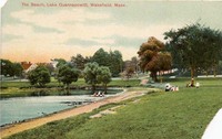 The beach, Lake Quannapowitt, Wakefield, Mass.
 Postcard shows a view looking east of the beach on the southern shore of Lake Quannapowitt.
-
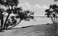
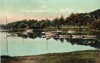
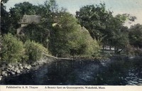 A beauty spot on Quannapowitt, Wakefield, Mass.
 Postcard shows a view of an unidentified spot on the shore of Lake Quannapowitt.
-
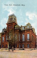 Town Hall, Wakefield, Mass.
 Postcard shows a view of Wakefield Town Hall, completed in 1871. The land and funds for the building were donated by industrialist Cyrus Wakefield, for whom the town is named. The building was demolished in 1958 after it was damaged by fire in December, 1950.
-
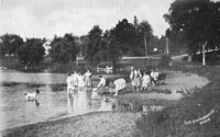 Lake Quannapowitt beach
 Postcard shows a view of the beach on the southern shore of Lake Quannapowitt.
-
 [Lake Quannapowitt, Wakefield, Mass.]
 Postcard shows a view looking north from the Common across Lake Quannapowitt.;"The beautiful lake named for a local Indian chief is popular for bathing, boating, and skating." -- Text from back of postcard.
-
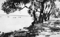 The elms beside Lake Quannapowitt, Wakefield, Mass.
 Postcard shows a view of elm trees along the Main Street shore of Lake Quannapowitt.
-
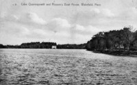 Lake Quannapowitt and Rosson's boat house, Wakefield, Mass.
 Postcard shows a view north over Lake Quannpowitt with Rosson's boat house on the far shore.
-
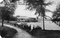
 Lake Quannapowitt view from boat house, Wakefield, Mass.
 Postcard shows a view of the dock at the boathouse at the end of Lake Street on the southern shore of Lake Quannapowitt.
-
 A glimpse of Quannapowitt from the Congregational Church tower, Wakefield, Mass.
 Postcard shows a view northeast from the Congregational Church tower towards Main Street.
-
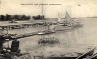 Quannapowitt Lake, Wakefield, Mass.
 Postcard shows a view of the dock at the boathouse at the end of Lake Street on the southern shore of Lake Quannapowitt.
-
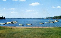
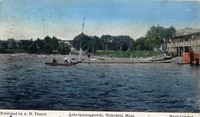
 Lake Quannapowitt, Wakefield, Mass.
 Postcard shows a view from the Common east towards Main Street of boats on Lake Quannapowitt.
-
 Lake Quannapowitt, Wakefield 1907
 Postcard shows a view of the dock at the boathouse at the end of Lake Street on the southern shore of Lake Quannapowitt.
-
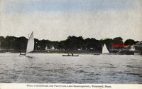 Wiley's Boathouse and Park from Lake Quannapowitt, Wakefield, Mass.
 Postcard shows a view of the boathouse at the end of Lake Street on the southern shore of Lake Quannapowitt.
-
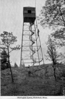
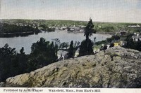
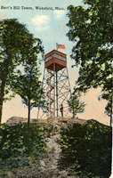 Hart's Hill tower, Wakefield, Mass.
 Postcard shows the Hart's Hill forest fire watch tower built at the summit of Hart's Hill in 1913 by the state Forestry Department. The tower was approximately 50 feet tall.
-
 Lake Quannapowitt, 1907
 Postcard shows a view of the dock at the boathouse at the end of Lake Street on the southern shore of Lake Quannapowitt.
-
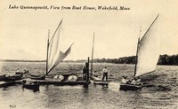
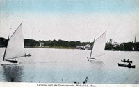 Yachting on Lake Quannapowitt, Wakefield, Mass.
 Postcard shows a view looking south across Lake Quannapowitt toward the Common. The boat house, Congregational Church and Baptist Church are visible on the far shore.
-
 Quannapowitt Lake, Wakefield, Mass.
 Postcard shows a view looking west from Main Street across the Common toward the boathouse at the end of Lake Street on the southern shore of Lake Quannapowitt.
-
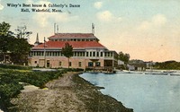 Wiley's Boat house & Cubberly's Dance Hall, Wakefield, Mass.
 Postcard shows a view looking west from Main Street across the Common toward the boathouse at the end of Lake Street on the southern shore of Lake Quannapowitt.
-
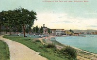 A glimpse of the park and lake, Wakefield, Mass.
 Postcard shows a view looking west from Main Street across the Common toward the boathouse at the end of Lake Street on the southern shore of Lake Quannapowitt.
-
 Lake Quannapowitt, Wakefield, Mass.
 Postcard shows a view looking west from Main Street toward the boathouse at the end of Lake Street on the southern shore of Lake Quannapowitt.;"Looking toward the old Boat House before it was torn down." -- Text from back of postcard.
-
 Lake Quannapowitt, Wakefield, Mass.
 Postcard shows a view looking east of boaters and the boathouse at the end of Lake Street on the southern shore of Lake Quannapowitt.
-
 Lake Quannapowitt waterfront and boat house, Wakefield, Mass.
 Postcard shows a view of boaters and the boathouse at the end of Lake Street on the southern shore of Lake Quannapowitt.
-
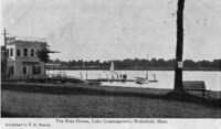 The boat house Lake Quannapowitt, Wakefield, Mass.
 Postcard shows a view of Wiley's boathouse at the end of Lake Street on the southern shore of Lake Quannapowitt.
-
 Lake Quannapowitt, Wakefield, Mass.
 Postcard shows a view looking west from Main Street over the southern shore of Lake Quannapowitt. Wiley's boathouse and the icehouses are visible in the distance on the opposite shore.
-
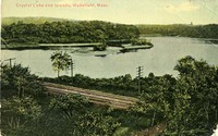
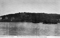 Hart's Hill and the islands Crystal Lake, Wakefield, Mass.
 Postcard shows a view over Crystal Lake looking east from the west shore. The rocky top of Hart's Hill is visible in the background above the houses on Main Street.
-
 Lake Quannapowitt, Wakefield, Mass.
 Postcard shows a view looking west from Main Street over the southern shore of Lake Quannapowitt. Wiley's boathouse is on the left. Lakeside Cemetery is visible in the distance on the opposite shore.
-
 Glimpse of the boat house Lake Quannapowitt, Wakefield, Mass.
 Postcard shows a view of Wiley's boathouse and the ice houses at the end of Lake Street on the southern shore of Lake Quannapowitt.
-
 Lake Quannapowitt, Wakefield, Mass.
 Postcard shows a view of Wiley's boathouse and the ice houses at the end of Lake Street on the southern shore of Lake Quannapowitt.
-
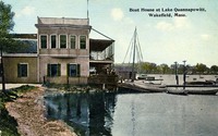 Boat house at Lake Quannapowitt, Wakefield, Mass.
 Postcard shows a view of Wiley's boathouse at the end of Lake Street on the southern shore of Lake Quannapowitt.
-
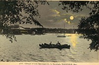 Glimpse of Lake Quannapowitt by moonlight, Wakefield, Mass.
 Postcard shows a view from Main Street looking west over the southern shore of Lake Quannapowitt. The Wiley boathouse and ice houses are visible in the background.
-
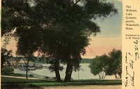 The Willows, Lake Quannapowitt, Wakefield, Mass.
 Postcard shows a view from Main Street looking west over the southern shore of Lake Quannapowitt. The Wiley boathouse and ice houses are visible in the background.
-
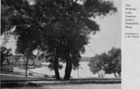 The Willows, Lake Quannapowitt, Wakefield, Mass.
 Postcard shows a view from Main Street looking west over the southern shore of Lake Quannapowitt. the Wiley boathouse and ice houses are visible in the background.
-
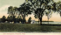 Lake Quannapowitt, Wakefield, Mass.
 Postcard shows a view north over Wakefield Common to Lake Quannapowitt. The Wiley Boathouse is visible in the background.
-
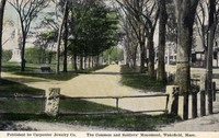 The Common and Soldiers' Monument, Wakefield, Mass.
 Postcard shows a view of Wakefield Common with the Soldiers and Sailors Memorial, erected in 1902 to commemorate Wakefield's Civil War casualties, in the background.
-
 Hart's Hill tower, Wakefield, Mass.
 Postcard shows the Hart's Hill forest fire watch tower built at the summit of Hart's Hill in 1913 by the state Forestry Department. The tower was approximately 50 feet tall.
-
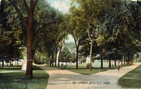
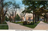 Wakefield Common, Wakefield, Mass.
-
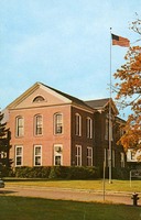 [Wakefield Town Hall]
 Postcard shows the Town Hall on Wakefield Common at Lafayette Street. Built in 1871, the building was used as the town's high school until 1937, when it was remodeled as part of a WPA project for municipal offices. The building is now also known as the Lafayette building.
-
 The Common, Wakefield, Mass.
-
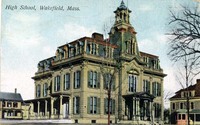
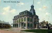
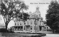 High School, Wakefield, Mass.
 Postcard shows the High School on Wakefield Common at Lafayette Street. Built in 1871, the building was used for school purposes until 1937, when it was remodeled as part of a WPA project for municipal offices. The building, also known as the Lafayette building, is now Wakefield's Town Hall.
-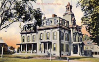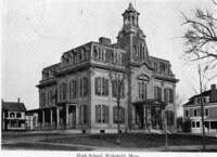
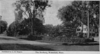
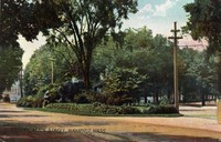
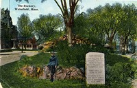
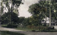 The Rockery, Wakefield, Mass.
 Postcard shows the Rockery on Main Street, looking north toward the Common.
-
 The Rockery, Wakefield, Mass.
 Postcard shows the Rockery on Main Street, looking north toward the Common.
-
 High School, Wakefield, Mass.
 Postcard shows the High School on Wakefield Common at Lafayette Street. Built in 1871, the building was used for school purposes until 1937, when it was remodeled as part of a WPA project for municipal offices. The building, also known as the Lafayette building, is now Wakefield's Town Hall.
-
 Rockery Main Street, Wakefield, Mass.
 Postcard shows the Rockery on Main Street, looking north.
-
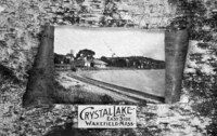
 Crystal Lake and islands, Wakefield, Mass.
 Postcard shows a view over Crystal Lake looking roughly southwest. The railroad line from Boston is visible in the foreground.
-
 High School, Wakefield, Mass.
 Postcard shows the High School on Wakefield Common at Lafayette Street. Built in 1871, the building was used for school purposes until 1937, when it was remodeled as part of a WPA project for municipal offices. The building, also known as the Lafayette building, is now Wakefield's Town Hall.
-
 The Rockery, Wakefield, Mass.
 Postcard shows the Rockery on Main Street, looking northwest. The High School is visible on the left. The text on the stone monument reads "Historical Linn Village 1639 Original town of Redding 1644 South Reading 1812 Wakefield 1868 Height above sea level 120 feet This stone is placed here by one hundred of the townspeople A.D. 1909."
-
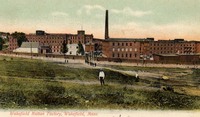 Wakefield Rattan Factory, Wakefield, Mass.
 Postcard shows the Heywood-Wakefield furniture factory complex on Water Street. The view is looking north, with Water Street visible in front of the factory buildings.
-
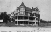 Crescent House, Wakefield, Mass.
 Postcard shows a view of the Crescent House rooming house located at 48 Water Street, at the corner of Crescent Street.
-
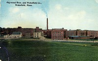 Haywood [i.e. Heywood] Bros. and Wakefield Co., Wakefield, Mass.
 Postcard shows the Heywood-Wakefield furniture factory complex on Water Street. The view is looking north, with Water Street visible in front of the factory buildings.
-
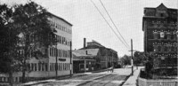 [L.B. Evans Son Company shoe factory, Wakefield, Mass.]
 Postcard shows a view looking west on Water Street toward Main Street. The L.B. Evans' Son Co. Shoe factory is on the left. The rear of the Miller Piano factory is visible on the right. The Evans factory building was sold in 1979 and the company phased out its operations. It has since been converted for office use.
-
 The Rockery, Wakefield, Mass.
 Postcard shows the Rockery on Main Street, looking northwest. The First Baptist Church is visible on the left.
-
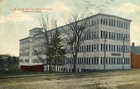 L.B. Evans Son Company shoe factory, Wakefield, Mass.
 Postcard shows a view of L.B. Evans' Son Co. Shoe Manufacturers on Water Street. The factory building was sold in 1979 and the company phased out its operations. It has since been converted for office use.
-
 The Rockery, Wakefield, Mass.
 Postcard shows the Rockery on Main Street, looking north toward the Common. The First Parish Congregational Church is visible in the background.
-
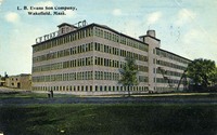 L.B. Evans Son Company, Wakefield, Mass.
 Postcard shows a view of L.B. Evans' Son Co. Shoe Manufacturers on Water Street. The factory building was sold in 1979 and the company phased out its operations. It has since been converted for office use.
-
 Birdseye view looking north from Hart's Hill Tower, Wakefield, Mass.
 Postcard shows a view over Crystal Lake looking northwest from the top of Hart's Hill. A portion of Main Street and the railroad tracks are visible in the foreground.
-
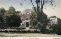 Y.M.C.A., Wakefield, Mass.
 Postcard shows a view of the YMCA building at the corner of Main Street and Yale Avenue. A portion of the Rockery is visible in the foreground.
-
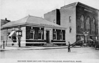 Savings Bank and Odd Fellows Building, Wakefield, Mass.
 Postcard shows the Wakefield Savings Bank building, at the corner of Main and Chestnut Streets. To the right is the 1895 Odd Fellows Building. Note the freestanding clock on the corner.
-
 The Y.M.C.A. Building, Wakefield, Mass.
 Postcard shows a view of the YMCA building at the corner of Main Street and Yale Avenue. A portion of the First Baptist Church is visible at the right.
-
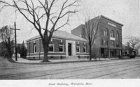 Bank building, Wakefield, Mass.
 Postcard shows the Wakefield National Bank building, at the corner of Main and Chestnut Streets. The location is now occupied by the Wakefield Savings Bank. To the right is the 1895 Odd Fellows Building.
-
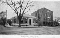
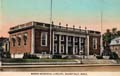 Beebe Memorial Library, Wakefield, Mass.
 Postcard shows the Lucius Beebe Memorial Library after opening in 1923.
-
 Bank building, Wakefield, Mass.
 Postcard shows the Wakefield National Bank building, at the corner of Main and Chestnut Streets. The location is now occupied by the Wakefield Savings Bank.
-
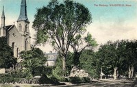
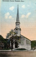 Universalist Church, Wakefield, Mass.
 Postcard shows a view of the Universalist Church on the east side of Main Street near the Rockery. The church was erected on that site in 1839. Major renovations in 1859 moved the building back from the street and added a new front portion and steeple. In 1879 the church was raised to accommodate a downstairs kitchen and vestry.
-
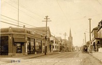
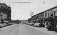
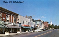 Main St., Wakefield
 Postcard shows a view of the west side of Main Street looking north from the intersection of Main and Lincoln Streets. The Fisher Jewelry store is visible in the Richardson Block at the left. Further up the street can be seen the Bourdon Block, the Wakefield Trust Company, Wakefield Savings Bank, and the Odd Fellows building. At the far north end is the steeple of the First Baptist Church.
-
 [Main Street, Wakefield Massachusetts]
 Postcard shows a view of the west side of Main Street looking north from the intersection of Main and Lincoln Streets. The Woolworth store is visible in the Richardson Block at the left. Further up the street can be seen the Bourdon Block, the Wakefield Trust Company, Wakefield Savings Bank, and the Odd Fellows building. At the far north end is the steeple of the First Baptist Church.
-
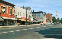
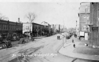
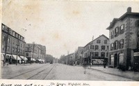 The Square, Wakefield, Mass.
 Postcard shows a view of Main Street looking south from the intersection of Main and Avon Streets. Albion Street can be seen on the right, flanked by the Perkins and Kingman (later Bourdon) Blocks.
-
 Wakefield, Mass. from Hart's Hill
 Postcard shows a view over Crystal Lake looking northwest from the top of Hart's Hill.
-
 Albion St., Wakefield, Mass.
 Postcard shows a view of Albion Street looking west from the intersection of Albion and Foster Streets. The Wakefield Daily Item building is visible on the left. In the distance can be seen the steeple of the Methodist Episcopal Church, which was toppled during the hurricane of 1938.
-
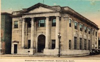 Wakefield Trust Company, Wakefield, Mass.
 Postcard shows a view of the Wakefield Trust Company building on the west side of Main Street at the corner of Main and Chestnut Streets. To the left of the bank can be seen a corner of the Kingman (later Bourdon) Block.
-
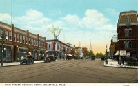
 Main Street, Wakefield, Massachusetts
 Postcard shows a view of Main Street looking south from the intersection of Main and Albion Streets. The Taylor Block can be seen on the left, and on the right in the middle distance is the Richardson Block, and in far distance the Olde Theatre Block.
-
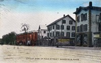
 [East side of Main Street, Wakefield, Mass.]
 Postcard shows a view of the east side of Main Street, between Centre and Princess Streets.
-
 [West side of Main Street, Wakefield, Mass.]
 Postcard shows a view of the west side of Main Street from the corner of Main and Lincoln Streets. To the right of the J.J. Newberry store is the Colonial Spa. In the middle, on the corner of Main and Albion Streets, is the Bourdon Block, followed by the Wakefield Trust Company and the Wakefield Savings Bank. The large brick building in the background is the Odd Fellows Building.
-
 West side of Main Street, Wakefield, Mass.
 Postcard shows a view of the west side of Main Street from roughly opposite the intersection of Main and Avon Streets. To the left of Albion Street is the Perkins Block, and to the right is the Kingman (later Bourdon) Block. The red brick building in the background is the 1860 Richardson Block.
-
 The Square, Wakefield, Mass.
 Postcard shows a view looking north up Main Street from the intersection of Main and Water Streets. At left is the Appleton building, later known as the Olde Theatre Block. Just beyond it is the Richardson Block. At the right is the Taylor Building, and on the extreme right edge can be seen a corner of the Town Hall. The steeple in the far distance belongs to the First Baptist Church.
-
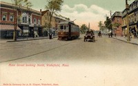 Main Street, looking north, Wakefield, Mass.
 Postcard shows a view looking north up Main Street from the intersection of Main and Water Streets. At left is the 1860 Richardson Block.
-
 Main Street, looking north, Wakefield, Mass.
 Postcard shows a view looking north up Main Street from the intersection of Main and Water Streets. At left is the Appleton building, later known as the Olde Theatre Block. Just beyond it is the Richardson Block. At the right is a corner of the Taylor Building. The steeple in the far distance belongs to the First Baptist Church.
-
 Bank Building, Wakefield, Mass.
 Postcard shows the Wakefield Savings Bank building, at the corner of Main and Chestnut Streets. To the right is the 1895 Odd Fellows Building.
-
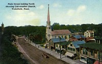 Main Street looking north showing Universalist Church, Wakefield, Mass.
 Postcard shows a view looking north up Main Street from the intersection of Main and Avon Streets. The Universalist Church, visible in the center, was erected on that site in 1839. Major renovations in 1859 moved the building back from the street and added a new front portion and steeple. In 1879 the church was raised to accommodate a downstairs kitchen and vestry. To the left can be seen the Rockery, in the middle of Main Street, and beyond, Wakefield Common and the tower of the First Parish Congregational Church.
-
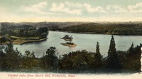 Crystal Lake from Hart's Hill, Wakefield, Mass.
 Postcard shows a view over Crystal Lake looking west from the top of Hart's Hill.
-
 Chickland Saugus Mass.
 "Chickland, Route 1 (North of Boston), Saugus, Massachusetts, Telephone: SAugus 8-0928. Chickland, famous throughout New England for its excellence in barbecued chicken. Open the year round from 12 noon. Closed Monday except Holidays. Dancing in main dining room. Cocktail lounge. Accommodations for your private parties up to 200 guests. Complete year-round air conditioning. Ample parking." -- Text from back of postcard.
-
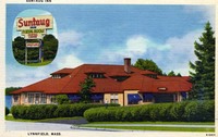 Suntaug Inn, Lynnfield Mass.
 "This famous Inn, on the shore of beautiful Lake Suntaug - on Route No. 128 and just off U.S. Route 1, at Lynnfield, Massachusetts - features dining and dancing, with music in the modern manner. All modern appointments, including cocktail lounge. Special daily luncheons. For reservations - Phone LYnn 3-8600." -- Text from back of postcard.
-
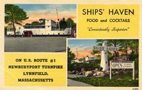 Ships' Haven, Lynnfield Mass.
 "Dinners * Cocktails * Luncheons. Ships' Haven. Completely air conditioned, Piers 24 and 26 Broadway, Route 1 (Newburyport Turnpike), Lynnfield, Mass. Attractive rooms for bridge, luncheon and dinner parties. Recommended by Duncan Hines, Gourmet, and Dartnell. Enjoy your drinks in a unique atmosphere. Closed Tuesdays. Telephone LYnn 3-6057." -- Text from back of postcard.
-
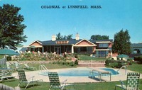 Colonial at Lynnfield Mass.
 "Colonial at Lynnfield, Mass., on Rte. 128 at Exit 21. Phone: CRystal 9-3042. New England's finest Public Country Club. Famous for Roast Prime Ribs. Six private dining rooms seating 1000 persons - four bars - beautiful outdoor terrace. Entertainment nightly. Excellent 9-hole Golf Course. George W. Page, Managing Director." - Text from back of postcard.
-
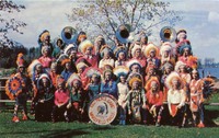 Red Men's Band
 "The famous and colorful Red Men's Band of Wakefield, Massachusetts. Wahpatuck Tribe No. 54 Improved Order of Red Men." -- Text from back of postcard.
-
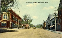 Wakefield Square, Wakefield, Mass.
 Postcard shows a view looking north up Main Street from the intersection of Main and Water Streets, in front of Town Hall. The Post Office can be seen in the Richardson Block on the left, and a portion of the Taylor Block is visible at the far right.
-
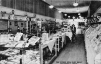 The Cubby Hole Gift Shop, Wakefield, Mass.
 Postcard shows a view of the interior of the Cubby Hole store, which existed in Wakefield at various locations from 1937 to 1992. This photo shows the store at 380 Main Street.;"Gifts, toys, greeting cards, stationery. Come in and get acquainted." -- Text from back of postcard.
-
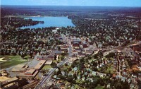 Air view of Wakefield
 Postcard shows an aerial view of Wakefield looking north up Main Street towards Lake Quannapowitt. In the foreground are the Junior High School and Atwell School. In the center of the photo is the Cyrus Wakefield Town Hall.
-
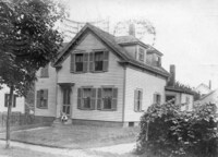
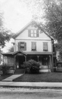 [Unidentified old house, Wakefield, Mass.]
 Postcard shows a view of an unidentified private home.
-
 [Unidentified old house, Wakefield, Mass.]
 Postcard shows a view of an unidentified private home.
-
 Crystal Lake east side, Wakefield, Mass.
-
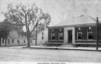
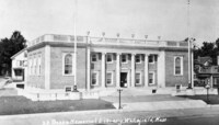 Beebe Memorial Library, Wakefield, Mass.
 Postcard shows the Lucius Beebe Memorial Library after opening in 1923.