
Swampscott Through the Years: A pictorial history
Item set
Items
1–100 of 118
Advanced search
-
 Fisherman's Beach, Swampscott, Mass. Fisherman's beach, the Fish House, and many beach goers enjoying the sun and sand.
 -
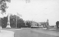
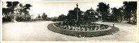 Monument Avenue Rotary, Swampscott, Mass. Rotary at Monument Avenue and Elmwood Road. Includes a view of the Mudge home known as Elmwood which was demolished in 1955.
 -
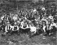
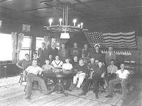 Young Yankee dory sailors and club officers Members of the Young Yankee Dory Sailors pose with officers of the Swampscott Yacht Club inside the club in this 1937 photograph. Appearing in the photo: Back row, L-R: 1. Ed Bergen, 2. Raymond Boynton, 3. King Dunwoody, 4. Frank R., 5. Barber Dunwoody, 6. Blaine Keho, Jr., 7. Forrest Mason. Seated, L-R: 1. Alan Howes, 2. Dick Hatfield, 3. Tom Rowen, 4. unknown, 5. Bill Gowell, 6. Alan Breed, 7. Charlie Coyle, 8. Oggie Keiser, 9. George White, 10. Rhet Moyes, 11. Kenneth Maree, 12. Bruce Durkee, 13. "Rags" Durkee.
 -
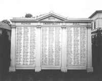 Swampscott honor roll Close up view of the Swampscott World War I honor roll memorial
 -
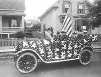 Sons of veterans parade float Five men and one boy ride in the "Sons of veterans" float--a car decorated with vines--during a local parade. The men are identified as Arthur E. Widger, Frank E. Morrison, Samuel Brandt, Mr. Keating, and Chester Glass. Photo taken by Stuart P. Ellis.
 -
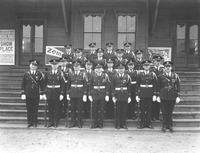 Swampscott American Legion drill team Members of the Swampscott American Legion drill team pose for a group portrait
 -
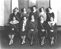 Swampscott American Legion auxiliary Members of the Swampscott American Legion auxiliary pose for a group portrait
 -
 Swampscott VFW at World War I memorial Members of Swampscott's VFW post pose in uniform at the World War I memorial A wreath has been laid at the site
 -
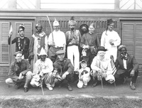 American Legion parade participants Participants in the American Legion parade of 1926 pose in costume
 -
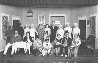 Swampscott American Legion show The cast of the 1929 Swampscott American Legion show pose in costume for a photo. Note some cast members dressed in drag. Front Row, L-R: 1. Unknown, 2. Winnie Doty, 3 & 4 unknown, 5. Louise Linden, 6. unknown, 7. Mrs. Al Jones. Back Row, L-R: 1 & 2 unknown, 3. Stanley Flagg, 4 - 6 unknown, 7. Harold Willett, 8. Fred Linden, 9. unknown, 10. Alfred Frazier.
 -
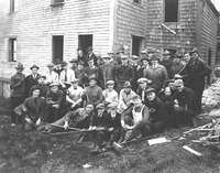 Swampscott American Legion renovation A group of men who have gathered to renovate the Swampscott American Legion building, pose with their tools by the building
 -
 World War I memorial with wreaths, Swampscott, Mass. Close up view of the Swampscott World War I memorial, a bronze plaque affixed to a large rock at the intersection of Burrill Street and Monument Avenue. The Chick and Ericson estates can be seen in the background. The memorial has been laid with wreaths.
 -
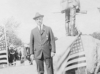 Man and statue A man wearing a medal on his suit poses for a picture behind a statue of a soldier. Flags fly on either side and, in the background, a crowd has gathered as if for a ceremony.
 -
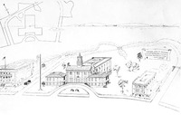
 Architectural drawing of proposed Soldiers' Memorial town hall : no.2 Architectural drawing showing plans for a proposed town hall to be built as a memorial to Swampscott's soldiers
 -
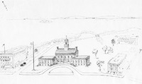
 Architectural drawing of proposed Soldiers' Memorial town hall : no. 1 Architectural drawing showing plans for a proposed town hall to be built as a memorial to Swampscott's soldiers
 -
 World War I cannon, Swampscott Cemetery, Swampscott, Mass. Close-up view of a World War I era cannon located in the veterans' plot of the Swampscott Cemetery
 -
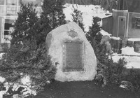 Revolutionary War Memorial, Swampscott, Mass. Swampscott's Revolutionary War memorial, also known as the Ramsdell Memorial "... is a boulder and bronze plaque in memory of the first soldier to die at the Battle of Lexington. Abednego Ramsdell was from that part of Lynn which became Swampscott and the Memorial is near the site of his home. Built in 1929 for Commonwealth's Tercentenary.----from Images of America : Swampscott, Turino and Mathias, 1996
 -
 World War I Veterans' Plot, Swampscott Cemetery Close-up view of the veterans' plot within the Swampscott Cemetery
 -
 World War I Memorial, Swampscott, Mass. Close up view of the Swampscott World War I memorial, a bronze plaque affixed to a large rock at the inersection of Burrill Street and Monument Avenue. The Chick and Ericson estates can be seen in the background.
 -
 Grand Army of the Republic parading Members of the Grand Army of the Republic participate in a local parade. Included in the photo are Peleg Gardner, John Merritt, and William S. Earp. Photo taken by Stuart P. Ellis.
 -
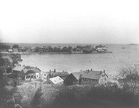 View of Swampscott, Massachusetts from Greenwood Avenue View of Swampscott from Greenwood Avenue looking Southeast toward Galloupe's Point
 -
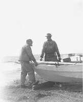
 Benjamin Martin and son with sailboat on Blaney Beach Benjamin Martin and his son and an unidentified man pose with a lapstrake sailboat on Blaney beach.--from Images of America : Swampscott, Turino and Mathias, 1996
 -
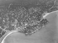 Aerial view of Swampscott, Mass. shoreline Aerial view looking Northeast across Swampscott from the ocean. King's Beach is on the left and Blaney Beach is on the right with Humphrey Street running alongside.
 -
 View of Swampscott, Massachusetts from Rockland Street View of Swampscott looking West from Rockland Avenue (?). The spire of the Congregational Church on Blaney Street appears on the left and the spire of the Methodist Church on on Redington Street appears in the center.
 -
 View of Swampscott, Massachusetts from Cherry Street hill View of Swampscott from the top of Cherry Street hill.
 -
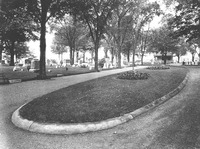
 Monument Square and Humphrey Street Monument Square was previously known as Mudge Square. The Mudge family donated the land for the erection of a Civil War monument in honor of the fourteen Swampscott men who died in the war. The monument is constructed of granite with bronze tables and trimmings. It is thirty feet high and six feet ten inches at the base. The monument was dedicated in 1883.--from Images of America : Swampscott, Turino and Mathias, 1996
 -
 Burrill Street and Monument Square Monument Square was previously known as Mudge Square. The Mudge family donated the land for the erection of a Civil War monument in honor of the fourteen Swampscott men who died in the war. The monument is constructed of granite with bronze tables and trimmings. It is thirty feet high and six feet ten inches at the base. The monument was dedicated in 1883.--from Images of America : Swampscott, Turino and Mathias, 1996
 -
 View of Swampscott, Massachusetts from Greenwood Avenue Oldest known view of Swampscott from Greenwood Avenue looking Southeast toward Galloupe's Point.
 -
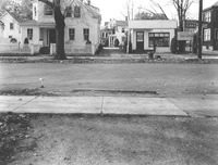
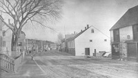
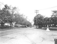 Intersection of Essex Street and Burrill Street View looking northeast along Essex Street at the intersection of Burrill Street. The streets are empty.
 -
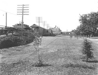 Swampscott depot yard, Columbia Street View of the grassy yard behind the Swampscott train station, adjacent to Columbia Street, which is on the Boston-bound side of the tracks.
 -
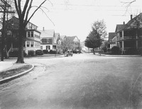 Paradise Road at Norfolk Avenue, 1932 View of a quiet residential neighborhood at the intersection of Paradise Road and Norfolk Avenue.
 -
 Essex Street, Stetson Avenue to cemetery View looking northeast along Essex Street from Stetson Avenue toward the Swampscott Cemetery.
 -
 Essex Street, Eastman Avenue to bridge View along Essex Street from Eastman Avenue.
 -
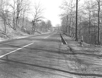
 Lynn Shore Drive at Eastern Avenue, 1930 View of Lynn Shore Drive looking east from Eastern Avenue.
 -
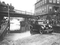 Flood of Burrill Street View of a flooded portion of Burrill Street at the railroad tressel, on which a train is passing by. Spectators stand on the raised sidewalk watching as one man stands on the sideboard of his automobile. Behind him, another man stands in thigh-deep water next to his partially-submerged automobile.
 -
 Auto show, 1921 Drivers sit in sleek, shiny cars parked side-by-side during a local car show.
 -
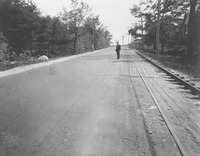 View of open road (Essex Street?) View down a long, straight road (Essex Street?). A man stands in the road and a woman stands to the side of the road in the distance. Railroad tracks run along the right side of the road.
 -
 View of open road (Essex Street) View down a long, straight road (Essex Street?) with an automobile in the distance. Railroad tracks run along the left side of the road.
 -
 Danvers Road bridge, view 1 Close-up view of the Danvers Road bridge from the roadway. A large building can be seen just over the top of the fence running alongside the bridge.
 -
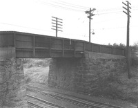 Danvers Road bridge, view 1 Close-up view of the Danvers Road bridge and the railroad tracks that it crosses over. The base of the bridge is stone and the barrier alongside the road is made of wood.
 -
 Burrill Street, 142-148 View of 142-148 Burrill Street from across the street. There is a residence to the left and a used car dealership to the right.
 -
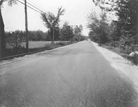
 Paradise Road, 1941 View along a paved Paradise Road in 1941. This location is approximately 331 Paradise Road, home of the Whole Foods Market (2008) and former site of the Foodmaster grocery store.
 -
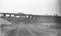 Paradise Road railroad trestle View of the wooden railroad trestle from Paradise Road.
 -
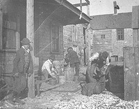
 Henry Leger and Ed Wiley split mackerel Partners Henry Leger and Ed Wiley split mackerel. Although one of the men had to walk with a cane, the two could still do a day's work. Transport is close at hand to take the cut fish up the beach to be salted."--from Images of America : Swampscott, Turino and Mathias, 1996
 -
 Henry and Jack Cullen and their Portuguese water dog Henry and Jack Cullen pose with an unidentified man and their Portuguese water dog near the Swampscott fishing shanties
 -
 Rodney A. Douglass Informal portrait of Rodney A Douglass
 -
 Alonzo Carey Alonzo Carey stands on Fishermen's (?) Beach in front of a lobster trap
 -
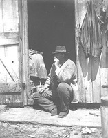
 John Slattery John Slattery works outside of a Swampscott fishhouse, while two men attend to tasks in the background and a boy looks on
 -
 John Chapman and Miles Blanchard Captain Miles Blanchard and John Chapman stand talking on either side of a fence
 -
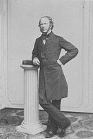 Portrait of Dr. Lawrence Portrait of Dr Lawrence
 -
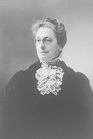
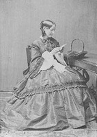 Portrait of Dr. Lawrence's wife Formal portrait of the wife of Dr Lawrence seated at a table doing needlepoint
 -
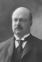 Portrait of John M. Grosvenor, Jr. Portrait of John M. Grosvenor, Jr. John Milton Grosvernor, Jr. was born in Woburn in 1864. He attended M.I.T. and became a chemist. Married Lilian Pitman Munson of Swampscott in 1894. Grosvenor was a junior member of the firm J.M. Grosvenor & Co., importers and manufacturing chemists, which was founded in 1868. He was the president and treasurer of the Annals Publishing Co., publishers of the Annals of Gynecology and Pediatry former chairman of the Republican Town Committee, park commissioner, a member of the Massachusetts House of Representatives (1904-05) and a member of the Massachusetts State Senate in 1906. Grosvenor was also an Essex County Commissioner beginning in 1907, a trustee of the Essex County Agricultural School.--from "Who's who in New England," edited by Albert Nelson Marquis, 1916.
 -
 Portrait of Sadie (Pierce) Hougton, Beach Street Formal portrait of Sadie (Pierce) Houghton of Beach Street, Swampscott, Massachusetts.
 -
 Portrait of Edward Albree Portrait of Edward Albree, 1885.
 -
 Portrait of Mrs. William Gaston Formal portrait of Mrs. Gaston, wife of the governor. Louisa Beecher was the daughter of Laban S. and Frances A. (Lines) Beecher. Her father was a lumber merchant in Roxbury, Mass. She married William Gaston on May 27, 1852 in Roxbury, MA. and had three children: Sarah Howard, Theodore Beecher, and William Alexander Gaston. Her husband, William Gaston, served as mayor of Roxbury (1861-1862) and of Boston (1871-1872). He was elected as governor of Massachusetts in 1875. After losing his bid for re-election, Gaston returned to his successful law practice in Roxbury. Gaston had also served as a Representative in the State Legislature (1853-1854), as Roxbury's City Solicitor (1856-60).--from the Official Massachusetts Governor biography (www.mass.gov) and Biographical history of Massachusetts : biographies and autobiographies of the leading men of the state, Samuel Atkins Eliot, 1909.
 -
 Gratin Martin and Jim Taylor Informal portrait of Gratin Martin and Jim Taylor standing on a sidewalk
 -
 Portrait of Mrs. Carl Wilhelm Ernst Format portrait of Abbie Snow (Hart) Ernst, only daughter of Thomas N. Hart, Mayor of Boston, from 1889 to 1890 and from 1900 to 1902
 -
 Portrait of William B. Phillips Portrait of fisherman William B. Phillips posing in his fishing gear in front of nets strung along a fence
 -
 Outing of Red Men Members of American Legion "Red Men" pose for a photo during an outing in June 1907
 -
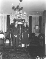 Portrait of Mr. and Mrs. Fred Sullivan Portrait of Mr. and Mrs. Fred Sullivan standing in their living room
 -
 Galloupe's Point ladies driven by Johnnie Hutt Two women from Galloupe's Point sit in a horse-drawn carriage driven by eight-year-old Johnnie Hutt--from Images of America : Swampscott, Turino and Mathias, 1996
 -
 William Murray, Frederic Lewis, Edward Albree, and Weston K. Lewis William Murray, Frederic H. Lewis, Edward Albree, and Weston K. Lewis walk along the beach pulling two small wagons. Murray carries a hammer in one hand and a saw in the other. Edward Albree and Weston K. Lewis worked at the Lincoln House stables, while Murray was a coachman.--from Then & now : Swampscott, Sue Ellen Woodcock, c2002.
 -
 Mrs. D. Holman Willett Mrs. D. Holman Willett and companions in front of 193 Humphrey Street. Four women sit in a horse drawn carriage, one stands on the porch and one stands with the horse.
 -
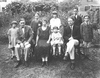 Portrait of the Stone family Portrait of Dick Stone and his family posing in their yard
 -
 Michael J. Ryan Michael J. Ryan sits in a horsedrawn carriage outside of a Swampscott residence
 -
 Portrait of Perley Kendrick, Abe Stone, and George Harris Portrait of Perley Kendrick, Abe Stone, and George Harris, seated with hats on their laps, in 1926
 -
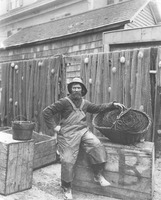
 Phil Crowley salting fish Fisherman "Phil Crowley salts down the split fish."--from Images of America : Swampscott, Turino and Mathias, 1996
 -
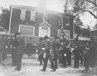
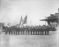 Grand Army of the Republic Members of the Grand Army of the Repbulic (GAR) pose in uniform and with flags in front of the Swampscott train station. Pictured are: Elmer Thomas, drummer, William Gardner, Eldrige Blaney, Joe Glass, Eben Martin, Orlando Pinkham, William Earp, Ed Marsh, John I. Adams, William Fay, George Connor, unidentified, James Alger, Peleg Gardner, Charles Rodrick, George Newhall, unidentified, Orlando Millett.
 -
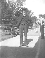
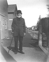
 James Wheeler Informal portrait of James Wheeler posing on a sidewalk.
 -
 John Smith in a fishhouse Fisherman John Smith inspects a barrel/float inside a fishhouse.
 -
 Portrait of Frank Nesbett Informal portrait of Frank Nesbett standing on a sidewalk with a dog.
 -
 Portrait of Charles Haskell, Ed Marsh, and Frank Nesbett Portrait of Charles Haskell a cobbler, Edward Marsh, a fisherman, and Frank Nesbett, a janitor.
 -
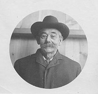 Portrait of Dick Gilley Portrait of Dick Gilley in a circular frame.
 -
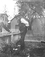
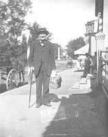
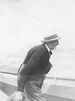 F.W. Brackett F.W. Brackett, dressed in foul weather gear, peering over a wall.
 -
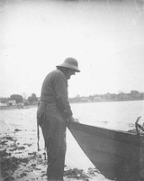 Eben Martin Fisherman Eben Martin leans on his dory at the water's edge.
 -
 Portrait of Solomon Abbott Informal portrait of fisherman Solomon Abbott
 -
 Charles Abbott and "Legs" Jones Fishermen, Charles Abbott and "Legs" Jones, stand on a beach leaning on a fishing dory.
 -
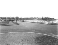
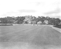 Blocksidge Field View of the Blocksidge playing field in 1936. Beyond the field, on a hill overlooking it, is the former Cook Estate on Ocean View Road.
 -
 '04' Franklin granddad "The Franklin motor car was invented by the engineer John Wilkinson and manufactured by the industrialist H. H. Franklin and marketed under his name. The Franklin was one of the most innovative motor cars of its time, featuring an air-cooled engine, scientific light weight and flexible construction at a time when other luxury car manufacturers were making ponderous machines. Throughout its history Franklin was a luxury car and it was in this part of the automotive market that it competed with the other notable makes of the day. As such it fell victim to the Great Depression along with many of these same fine luxury car manufacturers. These remarkable motor cars engendered such a loyal and faithful following that interest in these automobiles never died out. Many individuals continued to operate Franklins as their every day automobiles or preserved them right up to the emergence of the antique and classic hobby, decades after production ceased in 1934. The H. H. Franklin Manufacturing Company was a very large employer in Syracuse, New York area, its home base...--Onondaga Historical Association website, viewed 3/12/2008.
 -
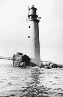 Graves Light, Boston Harbor; close-up view Graves Light is one of Massachusetts' youngest lighthouses. An iron bell buoy was placed near the ledges called the Graves in 1854. It was later replaced by a whistling buoy beyond the northeast end of the ledges. A new major shipping channel into Boston Harbor, the Broad Sound Channel, opened in the early 1900s, necessitating a lighthouse at the Graves. In 1902, Congress appropriated $75,000 for a lighthouse and fog signal, and Governor Crane of Massachusetts signed a deed conveying 435,400 square feet at the ledges to the federal government. The project ultimately cost $188,000, meaning a second appropriation of $113,000 was required in April 1904. Construction took place from 1903 to 1905, and Royal Luther of Malden, Massachusetts, was in charge. The style of Graves Light is very similar to Maine's Ram Island Ledge Light, built at about the same time. The granite for the tower was cut at Rockport on Cape Ann. Rock on the ledges was blasted, and the foundation was laid just four feet above the low tide mark. The first 42 feet were completed in the summer of 1903. While the granite was being put in place, the ironwork was being manufactured in Boston and a huge first-order Fresnel lens was being created in Paris. The summer of 1904 saw the lighthouse reach a height of 88 feet. Construction was completed during the following year. A granite oil house was built 90 feet south of the tower, reachable by a footbridge. On the night of September 1, 1905, Graves Light's first keeper, Elliot C. Hadley, lighted the most powerful light in Massachusetts history for the first time. The gigantic lens floated on 400 pounds of mercury. Storms and vandalism have done their share of damage. The old walkway has been destroyed by storms, and vandals have caused thousands of dollars in damage. The fog signal house was swept away by the "Perfect Storm" of October 1991. The badly damaged landing platform was repaired in 1993. The original oil house still stands. The submarine cable from the town of Hull that powered Grave
 -
 Graves Light, Boston Harbor Graves Light is one of Massachusetts' youngest lighthouses. An iron bell buoy was placed near the ledges called the Graves in 1854. It was later replaced by a whistling buoy beyond the northeast end of the ledges. A new major shipping channel into Boston Harbor, the Broad Sound Channel, opened in the early 1900s, necessitating a lighthouse at the Graves. In 1902, Congress appropriated $75,000 for a lighthouse and fog signal, and Governor Crane of Massachusetts signed a deed conveying 435,400 square feet at the ledges to the federal government. The project ultimately cost $188,000, meaning a second appropriation of $113,000 was required in April 1904. Construction took place from 1903 to 1905, and Royal Luther of Malden, Massachusetts, was in charge. The style of Graves Light is very similar to Maine's Ram Island Ledge Light, built at about the same time. The granite for the tower was cut at Rockport on Cape Ann. Rock on the ledges was blasted, and the foundation was laid just four feet above the low tide mark. The first 42 feet were completed in the summer of 1903. While the granite was being put in place, the ironwork was being manufactured in Boston and a huge first-order Fresnel lens was being created in Paris. The summer of 1904 saw the lighthouse reach a height of 88 feet. Construction was completed during the following year. A granite oil house was built 90 feet south of the tower, reachable by a footbridge. On the night of September 1, 1905, Graves Light's first keeper, Elliot C. Hadley, lighted the most powerful light in Massachusetts history for the first time. The gigantic lens floated on 400 pounds of mercury. Storms and vandalism have done their share of damage. The old walkway has been destroyed by storms, and vandals have caused thousands of dollars in damage. The fog signal house was swept away by the "Perfect Storm" of October 1991. The badly damaged landing platform was repaired in 1993. The original oil house still stands. The submarine cable from the town of Hull that powered Grave
 -
 Armistice Day Observance, 1931 A crowd observes Armistice Day (Veterans' Day) in Swampscott on November 11, 1931, commemorating the anniversary of the end of World War I in 1918. The town's memorial to World War I veterans is located at Monument Square. Monument Square is the park-like gateway to Swampscott and the entrance to the Olmsted Subdivision. Its center is the intersection of Humphrey Street, Monument Avenue, and Burrill Street and is marked by a tall obelisk on a green triangular traffic island. The 30-foot granite obelisk is the Civil War Monument dedicated in 1883 to honor the 14 from Swampscott who died in the Civil War.-- from Swampscott Reconnaissance Report, Massachusetts Department of Conservation and Recreation Essex National Heritage Commission, 2005.
 -
 Howland Park Howland Park is the site of Swampscott's World War II memorial. The memorial is named in honor of Raymond L. Howland (1895-1918), who died during WW I.
 -
 Carrie Phillips schooner Image showing the schooner Carrie E. Phillips under construction at the Arthur Story's Shipyard in Essex, MA. Piles of lumber lie in front of the ship and several men are visible on or near the vessel.
 -
 Omnibus and town pump on Humphrey Street Photograph shows a horse drawn omnibus and the town water pump. Several men are in the photo, which also shows the rear of some fish houses and a rowboat at the right.
 -
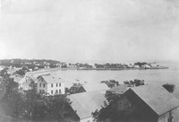
 Blaney Beach Photo of Blaney Beach in Swampscott taken around 1913.
 -
 Fish houses on Humphrey Street, 1896 Photograph of fish houses located on Humphrey Street in Swampscott in 1897. Photo is taken at close range and written across the bottom is "Blaney's Beach Swampscott, Mass."
 -
 Fish houses on Humphrey Street, 1890 Photograph of fish houses located on Humphrey Street in Swampscott in 1890
 -
 Distant view of Lincoln House Point Photograph of Lincoln House Point showing the Lincoln House in the background and breaking surf in the foreground
 -
 Dread Ledge Photograph of Dread Ledge in Swampscott taken from Galloupes's Point in 1885. There appears to be a gazebo at the far left.
 -
 Lincoln House Point, 1903 Photograph of Lincoln House Point showing the Lincoln House across Swampscott Harbor and some small boats in Swampscott Harbor in the foreground.
 -
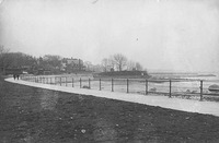
 Lynn Shore Drive at King's Beach Pedestrians walk along the Lynn Shore Drive promenade. A lone carriage approaches along the unpaved street.
 -
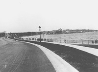
 View from Lynn Shore Drive toward Galloupe's Point Pedestrians walk on a promenade along Lynn Shore Drive at low tide. Galloupe's Point is in the distance.
 -
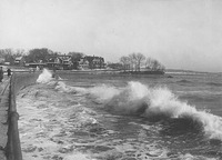
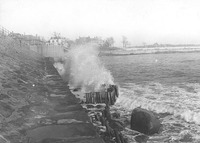 Surf breaking at Lynn Shore Drive Close-up view of surf crashing at the sea wall along Lynn Shore Drive.
 -
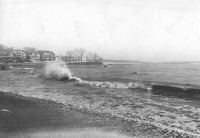
 Surf breaking along Lynn Shore Drive View of surf crashing at the sea wall along Lynn Shore Drive. Pedestrians in overcoats walk along the sidewalk.
 -
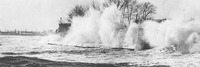
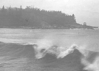
 Surf at Lynn Shore Drive View from King's Beach at Lynn Shore Drive toward Galloupe's Point with surf rolling in
 -
 Surf at Lynn Shore Drive breakwater Photo shows a sea wall at the bottom of a hill with waves crashing. There are several men walking or standing on the wall, as well as one dog.
 -
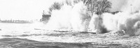 Surf crashing at Woodbury's Point;#2 Strong surf pounds the shore at Woodbury's Point
 -
 Surf crashing at Woodbury's Point Strong surf pounds the shore at Woodbury's Point
 -
 Galloupe's and Jeffrey's Points Surf crashes on the beach ahead of Galloupe's and Jeffrey's Points
1–100 of 118