-
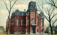
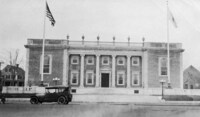 [Lucius Beebe Memorial Library, Wakefield, Mass.]
 Postcard shows the Lucius Beebe Memorial Library after opening in 1923.
-
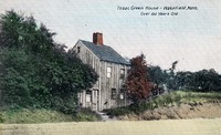 Isaac Green house, Wakefield, Mass. over 100 years old
 Postcard shows a view of the Isaac Green house in the Greenwood section of Wakefield on the east side of Main Street near the intersection with Green Street.
-
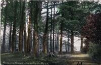
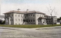 The new hospital, Melrose Mass.
 Postcard shows a view of the new hospital building located at the corner of Porter and Lebanon Streets. Built around 1911 at a cost of around $60,000, the new building could accommodate 75 patients. The Melrose-Wakefield Hospital, considerably expanded in size, is still located on the same site.
-
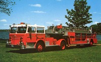 Ladder 1 Wakefield Massachusetts
 "1975 Maxim 100 foot aerial ladder. Diesel powered, automatic transmission. 200 gallon booster tank with 250 gpm P.T.O. Hale pump with 250 ft. of 3/4" booster hose & 150 ft. of 1 1/2" preconnected hose." -- Text from back of postcard.;Photo by L. Murray Young.
-
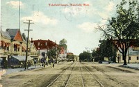 Wakefield Square, Wakefield, Mass.
 Postcard shows a view looking south down Main Street from the intersection of Main and Avon Streets.
-
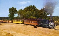 Highballing with Old Smokey at Pleasure Island
-
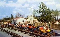 Drive yourself at Pleasure Island
-
 Old chowder house at Pleasure Island
-
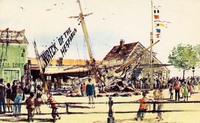 Wreck of the Hesperus, Pleasure Island
 Published for Breck's of Boston.;"Exit 21-A on Route 128, Wakefield, Mass." -- Text from back of postcard.
-
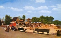
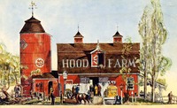 The Hood farm, Pleasure Island
 Published for Breck's of Boston.;"Exit 21-A on Route 128, Wakefield, Mass." -- Text from back of postcard.
-
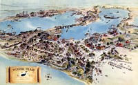 Bird's eye view of Pleasure Island
 Published for Breck's of Boston.;"Exit 21-A on Route 128, Wakefield, Mass." -- Text from back of postcard.
-
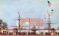 Entrance to Pleasure Island
 Published for Breck's of Boston.;"Exit 21-A on Route 128, Wakefield, Mass." -- Text from back of postcard.
-
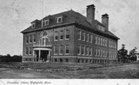
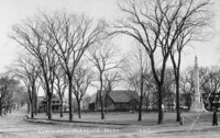
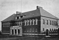 [Warren School, Wakefield, Mass.]
 Postcard shows the Warren School on Converse Street in Wakefield's West Side. The school was built in 1895 and was named in honor of Horace M. Warren, a resident who served with the Richardson Light Guard. It is now used as the Wakefield Senior Center.
-
 Greenwood School
 Postcard shows the Greenwood School on the east side of Main Street in the Greenwood section of Wakefield. The school was built in 1897, and remodeled and enlarged in 1902 and again in 1924.
-
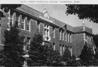 Saint Joseph Parochial School, Wakefield, Mass.
 Postcard shows the St. Joseph Parochial School on Gould Street, connected with St. Joseph's Roman Catholic Church on Albion Street.
-
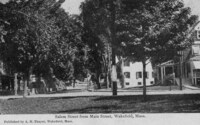
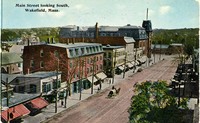 Main Street looking south, Wakefield, Mass.
 Postcard shows a view looking south down the east side of Main Street from the intersection of Main and Chestnut Streets. In the distance can be seen the intersection of Main and Water Streets. The large brick building in the background is the Taylor Block, behind which can be seen the tower of Town Hall.
-
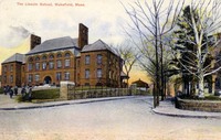
 Lincoln School, Wakefield, Mass.
 Postcard shows the Lincoln School at the corner of Crescent and Otis Streets. The school was built in 1892 and is now used for elderly housing.
-
 Franklin School, Wakefield, Mass.
 Postcard shows the Franklin School, built in 1902, on Nahant Street. The building was later remodeled and enlarged in 1925.
-
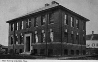 Hurd School, Wakefield, Mass.
 Postcard shows the Hurd School, built in 1899, at the corner of Cordis and Pleasant Streets.
-
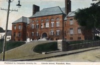
 The Lincoln School, Wakefield, Mass.
 Postcard shows the Lincoln School at the corner of Crescent and Otis Streets. The school was built in 1892 and is now used for elderly housing.
-
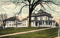 Cyrus Wakefield Estate, Wakefield, Mass.
 Postcard shows a view of the Cyrus Wakefield mansion once located on Main Street on the site of the present Galvin Middle School. The mansion was sited approximately opposite Richardson Street, on what is now the school parking lot. The stone house was built in the early 1860s in Second Empire style, and was complemented by a barn, gazebo, greenhouses, canals and orchards on the grounds which extended back to North Avenue.
-
 Wakefield High School, Wakefield, Mass.
 Postcard shows a view of Wakefield High School on Main Street at the location of the current Galvin Middle School parking lot. The building was opened in 1923 and was later known as the Atwell building in honor of Superintendent of Schools Willard B. Atwell. It was destroyed by fire on December 12, 1971.
-
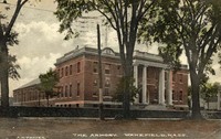
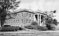 M.V.M. Armory, Wakefield, Mass.
 Postcard shows the Massachusetts State Armory on Main Street at the corner of Armory Street. The building was dedicated on January 15, 1913. In 1975 the town of Wakefield purchased the armory from the state for one dollar. It is now known as the Americal Civic Center and operated by the Americal Civic Center Association.
-
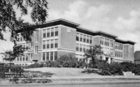
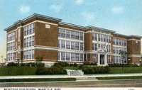
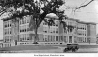 New High School, Wakefield, Mass.
 Postcard shows a view of Wakefield High School on Main Street at the location of the current Galvin Middle School parking lot. The building was opened in 1923 and was later known as the Atwell building in honor of Superintendent of Schools Willard B. Atwell. It was destroyed by fire on December 12, 1971.
-
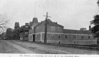 The armory, A Company, 6th Reg't., M.V.M., Wakefield, Massachusetts
 Postcard shows a view looking north up Main Street, with the Old Armory on the right. This armory predated the Massachusetts State Armory, built approximately across the street in 1913. The tower of the old Town Hall can be seen in the background.
-
 High School, Wakefield Massachusetts
 Postcard shows a view of Wakefield High School on Main Street at the location of the current Galvin Middle School parking lot. The building was opened in 1923 and was later known as the Atwell building in honor of Superintendent of Schools Willard B. Atwell. It was destroyed by fire on December 12, 1971.
-
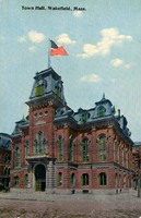
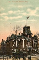
 Wakefield Town Hall, Wakefield, Mass.
 Postcard shows a view of Wakefield Town Hall, completed in 1871. The land and funds for the building were donated by industrialist Cyrus Wakefield, for whom the town is named. The building was demolished in 1958 after it was damaged by fire in December, 1950. Part of the Miller Piano Factory can be seen in the background.
-
 High School, Wakefield Massachusetts
 Postcard shows a view of Wakefield High School on Main Street at the location of the current Galvin Middle School parking lot. The building was opened in 1923 and was later known as the Atwell building in honor of Superintendent of Schools Willard B. Atwell. It was destroyed by fire on December 12, 1971. The Junior High School is visible in the left background.
-
 The armory Wakefield Massachusetts
-
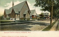
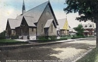
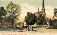
 Episcopal Church, Wakefield, Mass.
 Postcard shows a view of the Emmanuel Parish Episcopal Church on Main Street on the east side of Wakefield Common. The church was originally located on Water Street and was moved in 1900 to the corner of Main and Bryant Streets. The rectory was constructed in 1902. This view is looking west down Bryant Street toward the Common.
-
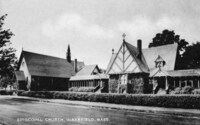
 Episcopal church & rectory, Wakefield, Mass.
 Postcard shows a view of the Emmanuel Parish Episcopal Church on Main Street on the east side of Wakefield Common. The church was originally located on Water Street and was moved in 1900 to the corner of Main and Bryant Streets. The rectory was constructed in 1902. This view is looking east up Bryant Street.
-
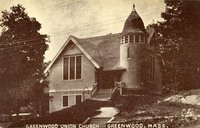 Greenwood Union Church Greenwood [Wakefield] Mass.
 Postcard shows a view of the Greenwood Union Church on Oak Street just off of Main Street in the Greenwood section of Wakefield. The building was built in 1895 and enlarged in 1922 and again in 1937. In 1961 a modern sanctuary was added to the original building.
-
 Episcopal church and rectory, Wakefield, Mass.
 Postcard shows a view of the Emmanuel Parish Episcopal Church on Main Street on the east side of Wakefield Common. The church was originally located on Water Street and was moved in 1900 to the corner of Main and Bryant Streets. The rectory was constructed in 1902. This view is looking east up Bryant Street.
-
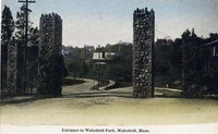 Entrance to Wakefield Park, Wakefield, Mass.
 Postcard shows a view of the stone entrance to the Wakefield Park residential area on Wakefield's West Side.
-
 View of Lake Quannapowitt from West's Hill, Wakefield, Mass.
 Postcard shows a view east towards Lake Quannapowitt from West's Hill.
-
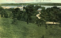
 A glimpse of Wakefield Park, Wakefield, Mass.
 Postcard shows a view of the Wakefield Park section in Wakefield's West Side.
-
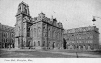
 Town Hall, Wakefield, Mass.
 Postcard shows a view of Wakefield Town Hall, completed in 1871. The land and funds for the building were donated by industrialist Cyrus Wakefield, for whom the town is named. The building was demolished in 1958 after it was damaged by fire in December, 1950.
-
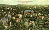 H.M. Warren School and vicinity, Wakefield, Mass.
 Postcard shows the Warren School on Converse Street in Wakefield's West Side. The school was built in 1895 and was named in honor of Horace M. Warren, a resident who served with the Richardson Light Guard. It is now used as the Wakefield Senior Center.
-
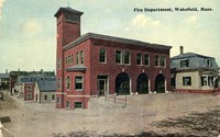 Fire department, Wakefield, Mass.
 Postcard shows a view of the 1900 Fire Department building at the corner of Crescent and Mechanic (now Princess) Streets. The view is looking west down Princess Street towards Main Street. Most of the building was torn down to make way for the 2004 Public Safety Building, which incorporated the brick hose tower into its design.
-
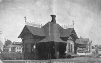 Greenwood Depot, Greenwood [Wakefield], Mass.
 Postcard shows a view of Wakefield's Greenwood Train Station on Main Street. The building was moved in 1959 to the Pleasure Island amusement park and was destroyed by fire in 1971.
-
 Hub Stove Foundry, Wakefield, Mass.
 Postcard shows a view of The Hub Stove Foundry building. The company was established by Cyrus Wakefield in 1854 on Foundry Street as the Boston & Maine Foundry Company. It later became the Smith and Anthony Stove Company.
-
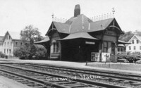 Greenwood Station
 Postcard shows a view of Wakefield's Greenwood Train Station on Main Street. The building was moved in 1959 to the Pleasure Island amusement park and was destroyed by fire in 1971.
-
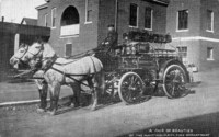 A pair of beauties of the Wakefield, Mass. fire department
 Postcard shows a horse-drawn fire engine of the Wakefield Fire Department. The fire house on Princess Street is visible in the background.
-
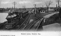 Wakefield Junction, Wakefield, Mass.
 Postcard shows a view of Wakefield's Junction Train Station at Main Street and North Avenue.
-
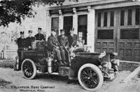 Volunteer Hose Company, Wakefield, Mass.
 Volunteer Hose Company No.2 became a part of the Wakefield Fire Department following a Town Meeting vote in March 1892.
-
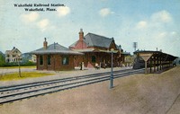
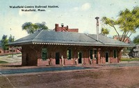 Wakefield Centre Railroad Station, Wakefield, Mass.
 Postcard shows a view of Wakefield's Center Train Station on Water Street.
-
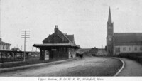 Upper Station B & M. R.R., Wakefield, Mass.
 Postcard shows a view of Wakefield's Upper Train Station on North Avenue looking south down Tuttle Street. St. Joseph's Roman Catholic Church is visible on the right.
-
 Town Hall, Wakefield, Mass.
 Postcard shows a view of Wakefield Town Hall, completed in 1871. The land and funds for the building were donated by industrialist Cyrus Wakefield, for whom the town is named. The building was demolished in 1958 after it was damaged by fire in December, 1950. Part of the Miller Piano Factory can be seen in the background.
-
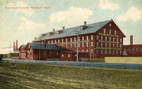
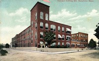 Harvard Knitting Mill, Wakefield, Mass.
 Postcard depicts the Harvard Knitting Mills complex looking south from the corner of Albion and Foundry Streets.
-
 "Tuttle Park", Wakefield, Mass.
 Postcard shows a view of a park in front of Wakefield's Upper Train Station looking south down Tuttle Street. St. Joseph's Roman Catholic Church can be seen on the right. North Avenue is just visible behind the train station.
-
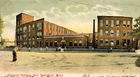 Harvard Knitting Mill, Wakefield, Mass.
 Postcard depicts the Harvard Knitting Mills complex looking south from across Albion Street.
-
 Wakefield Railroad Station, Wakefield, Mass.
 Postcard shows a view of Wakefield's Upper Train Station on North Avenue looking north from the intersection with Albion Street.
-
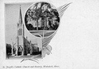 St. Joseph's Catholic Church and Rectory, Wakefield, Mass.
 Postcard shows views of St. Joseph's Church and its rectory. The Church was located at the corner of Albion and Tuttle Streets. The Rectory, built in 1885, was located just behind at the corner of Albion and Murray Streets. The church was destroyed by fire on March 24, 1977.
-
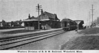 Western division of B & M. Railroad, Wakefield, Mass.
 Postcard shows a view of Wakefield's Upper Train Station on North Avenue looking north from the intersection with Albion Street.
-
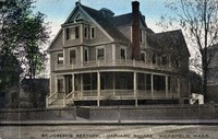 St. Joseph's Rectory, Harvard Square, Wakefield, Mass.
 Postcard shows a view of the rectory of St. Joseph's Church built in 1885 at the corner of Albion and Murray Streets. The area was known as Harvard Square because of the proximity of the Harvard Knitting Mill.
-
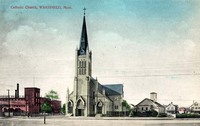
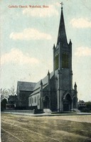
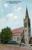
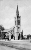 St. Joseph's Catholic Church, Wakefield, Mass.
 Postcard shows a view of St. Joseph's Church at the corner of Albion and Tuttle Streets. The building was destroyed by fire on March 24, 1977.
-
 Catholic Church, Wakefield, Mass.
 Postcard shows a view of St. Joseph's Church at the corner of Albion and Tuttle Streets. The building was destroyed by fire on March 24, 1977. Tuttle Street is in the foreground. On the left down Albion Street can be seen the Harvard Knitting Mills complex.
-
 Catholic Church, Wakefield, Mass.
 Postcard shows a view of St. Joseph's Church at the corner of Albion and Tuttle Streets. The building was destroyed by fire on March 24, 1977.
-
 Town Hall, Wakefield, Mass.
 Postcard shows a view of Wakefield Town Hall, completed in 1871. The land and funds for the building were donated by industrialist Cyrus Wakefield, for whom the town is named. The building was demolished in 1958 after it was damaged by fire in December, 1950. Part of the Miller Piano Factory can be seen in the background.
-
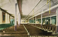 Interior, St. Joseph's R.C. [Roman Catholic] Church, Wakefield, Mass.
 Postcard shows a view of the side aisle of St. Joseph's Church at the corner of Albion and Tuttle Streets. The building was destroyed by fire on March 24, 1977.
-
 St. Joseph's Catholic Church, Wakefield, Mass.
 Postcard shows a view of the Albion Street side of St. Joseph's Church at the corner of Albion and Tuttle Streets. The building was destroyed by fire on March 24, 1977.
-
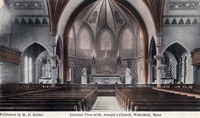
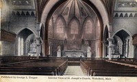 Interior view of St. Joseph's Church, Wakefield, Mass.
 Postcard shows a view of the nave and apse of St. Joseph's Church at the corner of Albion and Tuttle Streets. The building was destroyed by fire on March 24, 1977.
-
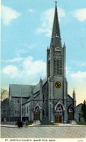 St. Joseph's Church, Wakefield, Mass.
 Postcard shows St. Joseph's Church at the corner of Albion and Tuttle Streets. The building was destroyed by fire on March 24, 1977.
-
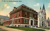 The Y.M.C.A. Building, Wakefield, Mass.
 Postcard shows a view of (left to right) the Wakefield YMCA, the First Baptist Church and the Lafayette Building (presently the William J. Lee Town Hall).
-
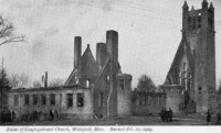 Ruins of Congregational Church, Wakefield, Mass., burned Feb 21. 1909
 Postcard shows the ruins of the Congregational Church on the west side of Wakefield Common. The view is looking east on Church street towards the common. The granite church, built in 1892, was the fourth church on the site. After its destruction by fire a new church of similar design was rebuilt and dedicated in 1912.
-
 [YMCA First Baptist Church and Lafayette Building, Wakefield, Mass.
 Postcard shows the west side of Main Street with the Wakefield YMCA on the left, the 1872 Baptist Church in the center, and the Lafayette Building (Town Hall) in the background behind the trees. On the right, in the center of Main Street, is the Rockery with the hiker statute, erected in 1926 to commorate Wakefield soldiers in the Spanish-American War.
-
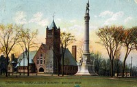 Congregational Church & Soldiers Monument, Wakefield, Mass.
 Postcard shows the Congregational Church on the west side of Wakefield Common. The granite church, built in 1892, was the fourth church on the site. It was destroyed by fire in 1909. A new church of similar design was rebuilt and dedicated in 1912. On the right is the Soldiers and Sailors Memorial, erected in 1902 to commemorate Wakefield's Civil War casualties.
-
 Baptist Church, Wakefield, Mass.
 Postcard shows the First Baptist Church on the west side of Wakefield Common. The church was organized in 1804 and the present building was built in 1872.;"Photo by William Keech."
-
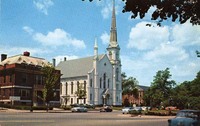
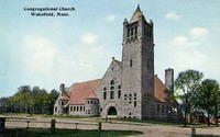 Congregational Church, Wakefield, Mass.
 Postcard shows the Congregational Church on the west side of Wakefield Common. The granite church is the fifth church on the site, and was dedicated on February 1, 1912.
-
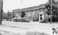
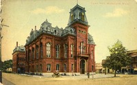
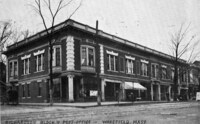 Richardson Block & Post Office, Wakefield, Mass.
 Postcard shows a view of the 1860 Richardson Block on the northwest corner of Main Street and Richardson Avenue. The Wakefield Post Office was located in the building from 1901 until 1924, when it moved to a building on Albion Street.
-
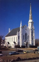
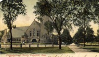 Congregational Church, Wakefield, Mass.
 Postcard shows the Congregational Church on the west side of Wakefield Common. The granite church, built in 1892, was the fourth church on the site. It was destroyed by fire in 1909. A new church of similar design was rebuilt and dedicated in 1912.
-
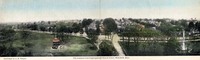 The Common from Congregational Church tower, Wakefield, Mass.
 Postcard shows a panoramic view of the Common looking east from the tower of the First Parish Congregational Church. Main Street runs from left to right, and Church Street divides the Common in the center of the view. On the left is the 1885 band stand and on the right the 1902 Soldiers' and Sailors' Memorial. At the extreme right the Lincoln School is visible in the distance.
-
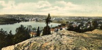 [Crystal Lake and Wakefield from Hart's Hill, Wakefield, Mass.]
 Postcard shows a view of Crystal Lake and Wakefield looking northwest from the top of Hart's Hill.
-
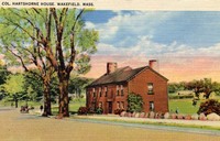
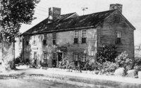 The Col. James Hartshorne House oldest in Wakefield was built 1681
 Postcard shows a view of the Hartshorne House looking west on Church Street. The home was originally built before 1680 and was enlarged or remodeled several times. It was deeded to the town in 1929 and is now maintained by the Col. James Hartshorne House Association.
-
 Common, Wakefield, Mass., 1647
 Postcard shows a view of the Common looking east up Church Street, which becomes Salem Street at the point where the houses are visible (the intersection with Main Street). In the center on Main Street is the Emmanuel Parish Episcopal Church, and on the right is the Soldiers and Sailors Memorial, erected in 1902 to commemorate Wakefield's Civil War casualties. The 1647 date on the card presumably refers to the year of the first land grants to settlers.
-
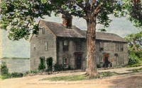 Colonel Hartshorne House, built 1663, Wakefield, Mass.
 Postcard shows a view of the Hartshorne House looking west on Church Street. The home was originally built before 1680 and was enlarged or remodeled several times. It was deeded to the town in 1929 and is now maintained by the Col. James Hartshorne House Association.
-
 Salem Street from Main Street, Wakefield, Mass.
 Postcard shows a view looking east up Salem Street from the intersection with Main Street at the Common.
-
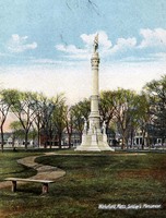
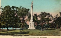
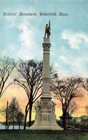 Soldiers' Monument, Wakefield, Mass.
 Postcard shows a view of Wakefield Common with the Soldiers and Sailors Memorial, erected in 1902 to commemorate Wakefield's Civil War casualties. The band stand is visible in the background.
-
 Col. Hartshorne House, Wakefield, Mass.
 Postcard shows a view of the Hartshorne House looking west on Church Street. The home was originally built before 1680 and was enlarged or remodeled several times. It was deeded to the town in 1929 and is now maintained by the Col. James Hartshorne House Association.
-
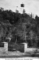 Entrance to Hart's Hill observatory, Wakefield, Mass.
 Postcard shows a view from the base of Hart's Hill looking up to the forest fire watch tower built at the summit in 1913 by the state Forestry Department. The tower was approximately 50 feet tall.
-
 Wakefield, Mass. Soldier's Monument
 Postcard shows a view of Wakefield Common with the Soldiers and Sailors Memorial, erected in 1902 to commemorate Wakefield's Civil War casualties.
-
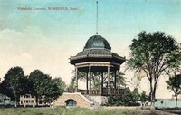 Wakefield Common, Wakefield, Mass.
 Postcard shows a view of the bandstand on the Common, built in 1885 at a cost of $2,500 as a replacement for an earlier wooden bandstand. The new bandstand was also known as the Pagoda and the Music Pavilion.
-
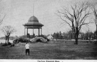 The park, Wakefield, Mass.
 Postcard shows a view of the bandstand on the Common, built in 1885 at a cost of $2,500 as a replacement for an earlier wooden bandstand. The new bandstand was also known as the Pagoda and the Music Pavilion.
-
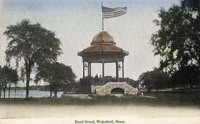
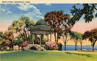 Band stand, Wakefield, Mass.
 Postcard shows a view of the bandstand on the Common, built in 1885 at a cost of $2,500 as a replacement for an earlier wooden bandstand. The new bandstand was also known as the Pagoda and the Music Pavilion.
-
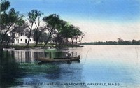 West shore of Lake Quannapowitt, Wakefield, Mass.
 Postcard shows a view of the west shore of Lake Quannapowitt.
-
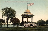 The pagoda and Lake Quannapowitt, Wakefield, Mass.
 Postcard shows a view of the bandstand on the Common, built in 1885 at a cost of $2,500 as a replacement for an earlier wooden bandstand. The new band stand was also known as the Pagoda and the Music Pavilion.
-
 Lake Quannapowitt from Church Street, Wakefield, Mass.
 Postcard shows a view of Lake Quannapowitt from Church Street on the southern shore.
-
 Band stand, Wakefield, Mass.
 Postcard shows a view of the bandstand on the Common, built in 1885 at a cost of $2,500 as a replacement for an earlier wooden bandstand. The new bandstand was also known as the Pagoda and the Music Pavilion.
-
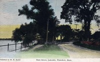 Main Street, lakeside, Wakefield, Mass.
 Postcard shows a view of the lakeside on the eastern shore of Lake Quannapowitt.
-
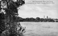 Lake Quannapowitt, Wiley's boat house, Congregational and Baptist churches, Wakefield, Mass.
 Postcard shows a view from the eastern shore of Lake Quannapowitt toward the Common.
-
 Town Hall, Wakefield, Mass.
-
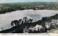 North End of Crystal Lake from Hart's Hill Tower, Wakefield, Mass.
 Postcard shows a view over Crystal Lake looking north from the top of Hart's Hill. Main Street is visible in the foreground. On the far shore the Crystal Lake water filtration plant can be seen. At the upper right the buildings of the Harvard Knitting Mills complex are visible.
-
 The Rockery, Wakefield, Mass.
 Postcard shows the Rockery on Main Street, looking north toward the Common.
-
 Baptist Church & Rockery, Wakefield, Mass.
 Postcard depicts a view northwest across Main Street towards the Baptist Church. The Rockery and High School (now Town Hall) are also visible.
-
 Soldiers and sailors memorial, Wakefield, Mass.
 Postcard shows the Soldiers and Sailors Memorial on the lower common, erected in 1902 to commemorate Wakefield's Civil War casualties.
-
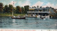 Lake Quannapowitt and park, Wakefield, Mass.
 Postcard shows Wiley's boat house on the shore of Lake Quannpowitt on Wakefield Common at the end of Spaulding Street.
-
 Spanish war monument and Rockery, Wakefield, Mass.
 Postcard shows the Rockery on Main Street, looking north. The statue known as "The Hiker", by Theo Alice Ruggles Kitson, was dedicated on October 12, 1926 in honor of Wakefield citizens who took part in the Spanish-American War.
-
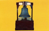 [Paul Revere bell]
 Postcard shows the large "Paul Revere bell", formerly on display at the Lucius Beebe Memorial Library. The bell is famous in town because it was made by the firm of Paul Revere. The work was probably done by his son, Joseph, but the bell is considered an original Revere bell because it was cast during his lifetime. The bell, weighing "about eight hundred and fifty weight", was purchased in 1815 by the town of South Reading for the parish for $350. The bell was hung in steeple of the First Parish Congregational Meeting House. In 1859 it was moved to the cupola of the Town's meeting hall on Church Street. The town hall was moved in 1871 to the corner of Main and Salem Streets and the bell moved with it. In 1888 is was moved to the new High School, what is now the William Lee Memorial Town Hall (Lafayette Building). In 1930 the bell was relocated to the lower lobby of Beebe Library, and in 1973 was brought up to the main floor lobby in the historic part of the building. The bell was transferred to the Wakefield Savings Bank during the Library's renovation and reconstruction in 1997. Later, it was moved to the lobby of the Galvin Middle School, where it remains today.
-
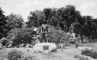
 Rosson's Grove, Wakefield, Mass.
 Postcard shows Rosson's Grove, located at the northern end of Lake Quannapowitt.
-
 Interior view of St. Joseph's church, Wakefield, Mass.
 Postcard shows the interior of St. Joseph's Church at the corner of Albion and Tuttle Streets. The building was destroyed by fire on March 24, 1977.