
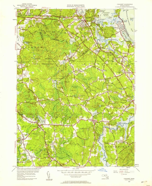
Cohasset quadrangle, Massachusetts / Mapped, edited, and published by the Geological Survey
Item
- Title
- Description
- Contributor
- Creator
- Format
- Identifier
- Publisher
- Type
- Original Format
- Extent
-
Cohasset quadrangle, Massachusetts / Mapped, edited, and published by the Geological Survey
-
Cohasset, Mass
-
View map in pdf format
-
Scale 1:24,000
-
Polyconic projection
-
Topography by planetable surveys 1935-1936. Revised 1947.
-
Filing title: Cohasset, Mass.
-
Relief shown by contours and spot heights
-
Contour interval 10 feet
-
Depth curves and soundings in feet
-
In upper margin: State of Massachusetts, Department of Public Works
-
N4207.5--W7045/7.5
-
Series V814
-
7.5 minute series (topographic)
-
Institution: Gloucester Lyceum & Sawyer Free Library
-
Massachusetts. Department of Public Works
-
Geological Survey (U.S.)
-
application/pdf
-
3552625
-
Washington, D.C. : U.S. Geological Survey
-
cartographic
-
Maps
-
Topographic maps
-
1 map : color
-
sheet 69 x 56 cm
- Item sets
- Gloucester Map Collection
- Media
 AS011_640.jpg
Position: 635 (195 views)