
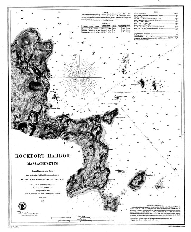
Rockport Harbor, Massachusetts
Item
- Title
- Description
- Contributor
- Creator
- Format
- Identifier
- Publisher
- Type
- Original Format
- Extent
-
Rockport Harbor, Massachusetts
-
View map in pdf format
-
Scale 1:20,000
-
From an trigonometrical survey under the direction of A.D. Bache, Superintendent of the survey of the coast of the United States
-
Triangulation by C.O. Boutelle, Assistant; topography by H.L. Whiting, Asst.
-
hydrography by the party under the command of Lieut. Comdg. C.H.P. Rodgers, U.S.N. Asst.
-
Aids to navigation corrected to 1882
-
Originally published in 1859, reissued March 1882, J.E. Hilgard, Supt.
-
Institution: Gloucester Lyceum & Sawyer Free Library
-
U.S. Coast and Geodetic Survey
-
application/pdf
-
3550574
-
Washington, D.C. : United States Coast and Geodetic Survey
-
cartographic
-
Maps
-
1 map : b&w
-
56 x 47 cm.
- Item sets
- Gloucester Map Collection
- Media
 AS027_640.jpg
Position: 2214 (114 views)