
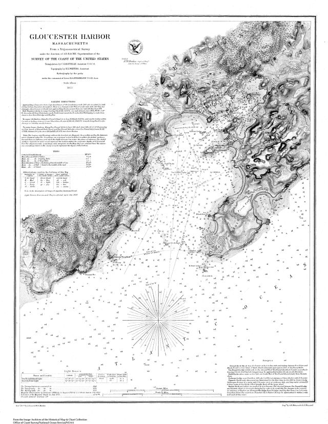
Gloucester Harbor, Massachusetts / from a trigonometrical survey under the direction of A.D. Bache, superintendent of the Survey of the Coast of the United States
Item
- Title
- Description
- Contributor
- Creator
- Format
- Identifier
- Publisher
- Subject
- Type
- Original Format
- Extent
-
Gloucester Harbor, Massachusetts / from a trigonometrical survey under the direction of A.D. Bache, superintendent of the Survey of the Coast of the United States
-
View map in pdf format
-
Scale 1:20,000
-
Facsimile
-
Relief shown by hachures. Depths shown by contours and soundings.
-
American Revolution Bicentennial, 1776-1976
-
BiC-18; Includes sailing information
-
Light houses, beacons, and buoys corr. up to Jan. 1875
-
Institution: Gloucester Lyceum & Sawyer Free Library
-
Bache, A. D. (Alexander Dallas), 1806-1867
-
National Ocean Survey
-
U.S. Coast and Geodetic Survey
-
application/pdf
-
3550567
-
Washington : U.S. Dept. of Commerce National Oceanic and Atmospheric Administration National Ocean Survey
-
Harbors
-
cartographic
-
Maps
-
Facsimiles
-
1 map : b&w
-
46 x 36 cm.
- Item sets
- Gloucester Map Collection
- Media
 AS006_640.jpg
Position: 1241 (151 views)