
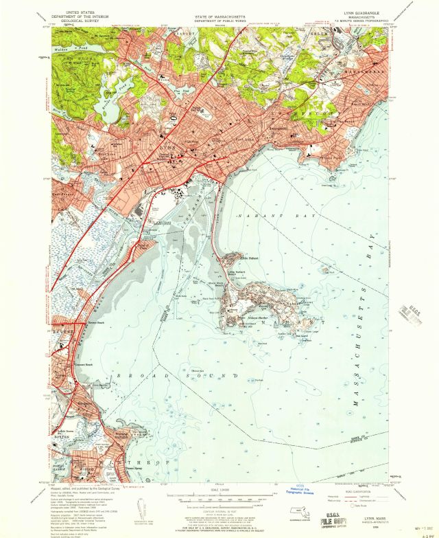
Lynn quadrangle, Massachusetts / Mapped, edited and published by the Geological Survey.
Item
- Title
- Description
- Contributor
- Creator
- Format
- Identifier
- Publisher
- Type
- Original Format
- Extent
-
Lynn quadrangle, Massachusetts / Mapped, edited and published by the Geological Survey.
-
Lynn, Mass.
-
View map in pdf format
-
Scale 1:24,000
-
Relief shown by contours and spot heights.
-
Contour interval 10 feet
-
Culture and drainage in part compiled from aerial photographs taken 1939. Topography by planetable surveys 1943. Culture revised by photogrammetric methods from aerial photographs taken 1955. Field check 1956.
-
Includes quadrangle location map
-
Also includes parts of Suffolk County and the Massachusetts bay
-
At head of map: State of Massachusetts, Department of Public Works.
-
N4222.5--W7052.5/7.5
-
7.5 minute series (topographic)
-
Institution: Gloucester Lyceum & Sawyer Free Library
-
Massachusetts. Department of Public Works
-
Geological Survey (U.S.)
-
application/pdf
-
3550139
-
Washington, D.C. : U.S. Dept. of the Interior Geological Survey
-
cartographic
-
Maps
-
Topographic maps
-
1 map : color
-
58 x 43 cm.
- Item sets
- Gloucester Map Collection
- Media
 AS021_640.jpg
Position: 1744 (128 views)