
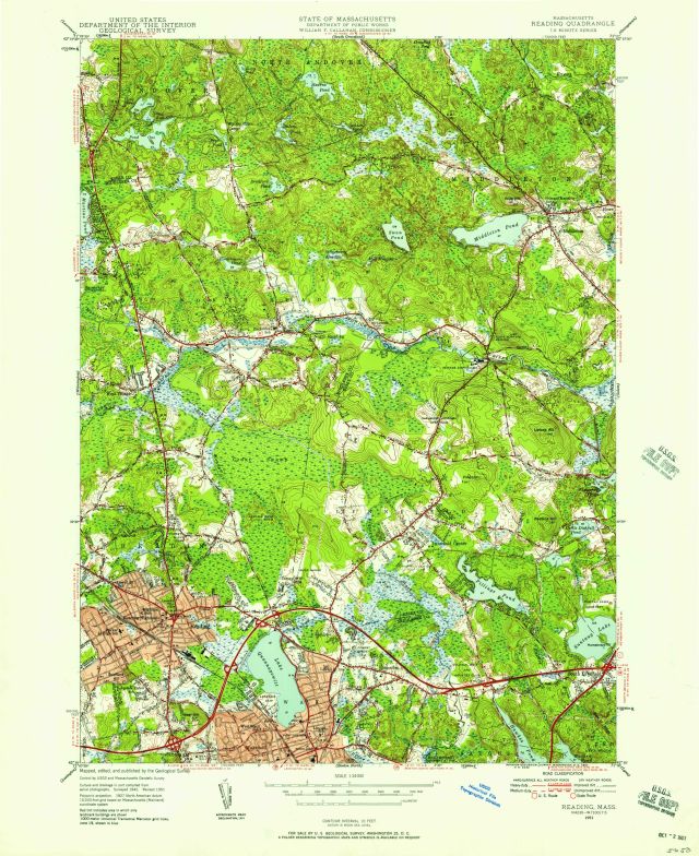
Massachusetts Reading quadrangle / Mapped, edited, and published by the Geological Survey
Item
- Title
- Description
- Contributor
- Creator
- Format
- Identifier
- Publisher
- Type
- Original Format
- Extent
-
Massachusetts Reading quadrangle / Mapped, edited, and published by the Geological Survey
-
View map in pdf format
-
Scale 1:24,000
-
Polyconic projection
-
Shows Reading and surrounding towns of North Andover, Andover, Middleton, North Reading, Peabody, Lynnfield, and Wakefield as well as ponds, lakes, rivers, roads, landmarks, and vegetation.
-
Relief shown by contours, shading and spot heights
-
Contour interval 10 feet
-
At top of map: State of Massachusetts Department of Public Works William F Callahan, Commissioner
-
Surveyed 1942. Revised 1951.
-
1000-meter Universal Transverse Mercator grid ticks, zone 19, shown in blue
-
N4230--W7100/7.5
-
7.5 minute series (topographic)
-
Institution: Gloucester Lyceum & Sawyer Free Library
-
Callahan, William F.
-
Massachusetts. Department of Public Works
-
Geological Survey (U.S.)
-
application/pdf
-
3549861
-
Washington, D.C. : U.S. Dept. of the Interior Geological Survey
-
cartographic
-
Maps
-
Topographic maps
-
1 map : color
-
58 x 43 cm.
- Item sets
- Gloucester Map Collection
- Media
 AS019_640.jpg
Position: 2313 (112 views)