
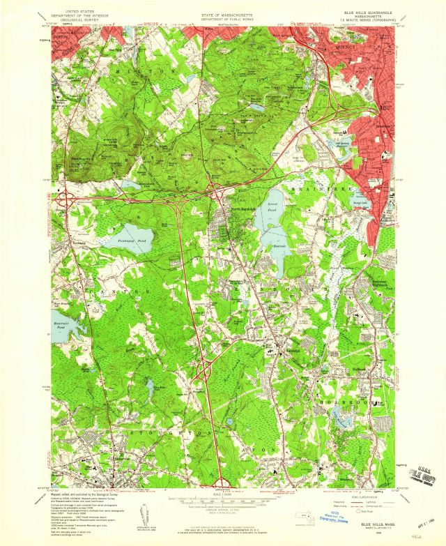
Blue Hills quadrangle, Massachusetts [1958] / Mapped, edited, and published by the Geological Survey ; [prepared in cooperation with the Commonwealth of Massachusetts Department of Public Works]
Item
- Title
- Description
- Contributor
- Creator
- Format
- Identifier
- Publisher
- Type
- Original Format
- Extent
-
Blue Hills quadrangle, Massachusetts [1958] / Mapped, edited, and published by the Geological Survey ; [prepared in cooperation with the Commonwealth of Massachusetts Department of Public Works]
-
Blue Hills, Mass
-
View map in pdf format
-
Scale 1:24,000
-
Culture revised by photogrammetric methods from aerial photographs taken 1957. Field check 1958.
-
Filing title: Blue Hills, Mass.
-
In upper margin: State of Massachusetts, Department of Public Works
-
Relief shown by contours and spot heights
-
Contour interval 10 feet
-
N4207.4--W7100/7.5
-
AMS 6768 II NE--Series V814
-
Standard map series designation: Series V814
-
Includes quadrangle location map
-
7.5 minute series (topographic)
-
Institution: Gloucester Lyceum & Sawyer Free Library
-
Massachusetts. Department of Public Works
-
Geological Survey (U.S.)
-
application/pdf
-
3549688
-
Washington, D.C : The Survey
-
cartographic
-
Maps
-
Topographic maps
-
1 map : color
-
sheet 69 x 56 cm.
- Item sets
- Gloucester Map Collection
- Media
 AS010_640.jpg
Position: 1454 (139 views)