-
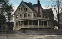 St. Joseph's Rectory, Harvard Square, Wakefield, Mass.
 Postcard shows a view of the rectory of St. Joseph's Church built in 1885 at the corner of Albion and Murray Streets. The area was known as Harvard Square because of the proximity of the Harvard Knitting Mill.
-
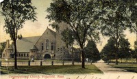
 St. Joseph's Catholic Church, Wakefield, Mass.
 Postcard shows a view of St. Joseph's Church at the corner of Albion and Tuttle Streets. The building was destroyed by fire on March 24, 1977.
-
 Catholic Church, Wakefield, Mass.
 Postcard shows a view of St. Joseph's Church at the corner of Albion and Tuttle Streets. The building was destroyed by fire on March 24, 1977. Tuttle Street is in the foreground. On the left down Albion Street can be seen the Harvard Knitting Mills complex.
-
 Catholic Church, Wakefield, Mass.
 Postcard shows a view of St. Joseph's Church at the corner of Albion and Tuttle Streets. The building was destroyed by fire on March 24, 1977.
-
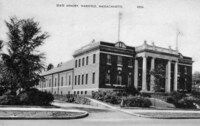
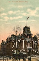 Town Hall, Wakefield, Mass.
 Postcard shows a view of Wakefield Town Hall, completed in 1871. The land and funds for the building were donated by industrialist Cyrus Wakefield, for whom the town is named. The building was demolished in 1958 after it was damaged by fire in December, 1950. Part of the Miller Piano Factory can be seen in the background.
-
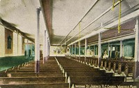 Interior, St. Joseph's R.C. [Roman Catholic] Church, Wakefield, Mass.
 Postcard shows a view of the side aisle of St. Joseph's Church at the corner of Albion and Tuttle Streets. The building was destroyed by fire on March 24, 1977.
-
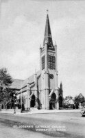
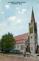 St. Joseph's Catholic Church, Wakefield, Mass.
 Postcard shows a view of the Albion Street side of St. Joseph's Church at the corner of Albion and Tuttle Streets. The building was destroyed by fire on March 24, 1977.
-
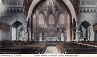
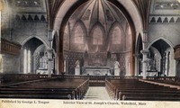 Interior view of St. Joseph's Church, Wakefield, Mass.
 Postcard shows a view of the nave and apse of St. Joseph's Church at the corner of Albion and Tuttle Streets. The building was destroyed by fire on March 24, 1977.
-
 St. Joseph's Church, Wakefield, Mass.
 Postcard shows St. Joseph's Church at the corner of Albion and Tuttle Streets. The building was destroyed by fire on March 24, 1977.
-
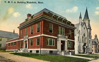 The Y.M.C.A. Building, Wakefield, Mass.
 Postcard shows a view of (left to right) the Wakefield YMCA, the First Baptist Church and the Lafayette Building (presently the William J. Lee Town Hall).
-
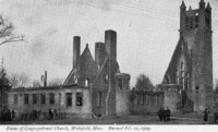 Ruins of Congregational Church, Wakefield, Mass., burned Feb 21. 1909
 Postcard shows the ruins of the Congregational Church on the west side of Wakefield Common. The view is looking east on Church street towards the common. The granite church, built in 1892, was the fourth church on the site. After its destruction by fire a new church of similar design was rebuilt and dedicated in 1912.
-
 [YMCA First Baptist Church and Lafayette Building, Wakefield, Mass.
 Postcard shows the west side of Main Street with the Wakefield YMCA on the left, the 1872 Baptist Church in the center, and the Lafayette Building (Town Hall) in the background behind the trees. On the right, in the center of Main Street, is the Rockery with the hiker statute, erected in 1926 to commorate Wakefield soldiers in the Spanish-American War.
-
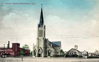
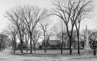
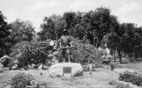
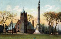 Congregational Church & Soldiers Monument, Wakefield, Mass.
 Postcard shows the Congregational Church on the west side of Wakefield Common. The granite church, built in 1892, was the fourth church on the site. It was destroyed by fire in 1909. A new church of similar design was rebuilt and dedicated in 1912. On the right is the Soldiers and Sailors Memorial, erected in 1902 to commemorate Wakefield's Civil War casualties.
-
 Baptist Church, Wakefield, Mass.
 Postcard shows the First Baptist Church on the west side of Wakefield Common. The church was organized in 1804 and the present building was built in 1872.;"Photo by William Keech."
-
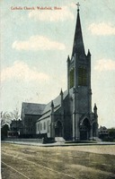
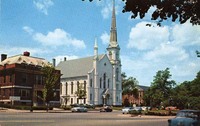
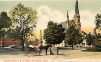
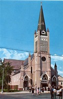
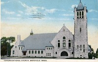
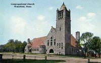 Congregational Church, Wakefield, Mass.
 Postcard shows the Congregational Church on the west side of Wakefield Common. The granite church is the fifth church on the site, and was dedicated on February 1, 1912.
-
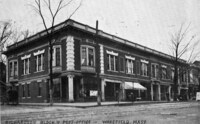 Richardson Block & Post Office, Wakefield, Mass.
 Postcard shows a view of the 1860 Richardson Block on the northwest corner of Main Street and Richardson Avenue. The Wakefield Post Office was located in the building from 1901 until 1924, when it moved to a building on Albion Street.
-
 Congregational Church, Wakefield, Mass.
 Postcard shows the Congregational Church on the west side of Wakefield Common. The granite church, built in 1892, was the fourth church on the site. It was destroyed by fire in 1909. A new church of similar design was rebuilt and dedicated in 1912.
-
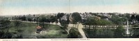 The Common from Congregational Church tower, Wakefield, Mass.
 Postcard shows a panoramic view of the Common looking east from the tower of the First Parish Congregational Church. Main Street runs from left to right, and Church Street divides the Common in the center of the view. On the left is the 1885 band stand and on the right the 1902 Soldiers' and Sailors' Memorial. At the extreme right the Lincoln School is visible in the distance.
-
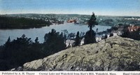
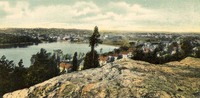 [Crystal Lake and Wakefield from Hart's Hill, Wakefield, Mass.]
 Postcard shows a view of Crystal Lake and Wakefield looking northwest from the top of Hart's Hill.
-
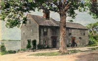
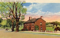
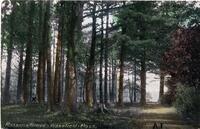
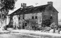 The Col. James Hartshorne House oldest in Wakefield was built 1681
 Postcard shows a view of the Hartshorne House looking west on Church Street. The home was originally built before 1680 and was enlarged or remodeled several times. It was deeded to the town in 1929 and is now maintained by the Col. James Hartshorne House Association.
-
 Common, Wakefield, Mass., 1647
 Postcard shows a view of the Common looking east up Church Street, which becomes Salem Street at the point where the houses are visible (the intersection with Main Street). In the center on Main Street is the Emmanuel Parish Episcopal Church, and on the right is the Soldiers and Sailors Memorial, erected in 1902 to commemorate Wakefield's Civil War casualties. The 1647 date on the card presumably refers to the year of the first land grants to settlers.
-
 Colonel Hartshorne House, built 1663, Wakefield, Mass.
 Postcard shows a view of the Hartshorne House looking west on Church Street. The home was originally built before 1680 and was enlarged or remodeled several times. It was deeded to the town in 1929 and is now maintained by the Col. James Hartshorne House Association.
-
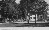 Salem Street from Main Street, Wakefield, Mass.
 Postcard shows a view looking east up Salem Street from the intersection with Main Street at the Common.
-
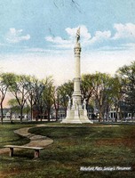
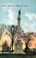 Soldiers' Monument, Wakefield, Mass.
 Postcard shows a view of Wakefield Common with the Soldiers and Sailors Memorial, erected in 1902 to commemorate Wakefield's Civil War casualties. The band stand is visible in the background.
-
 Col. Hartshorne House, Wakefield, Mass.
 Postcard shows a view of the Hartshorne House looking west on Church Street. The home was originally built before 1680 and was enlarged or remodeled several times. It was deeded to the town in 1929 and is now maintained by the Col. James Hartshorne House Association.
-
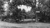
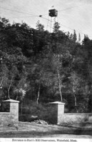 Entrance to Hart's Hill observatory, Wakefield, Mass.
 Postcard shows a view from the base of Hart's Hill looking up to the forest fire watch tower built at the summit in 1913 by the state Forestry Department. The tower was approximately 50 feet tall.
-
 Wakefield, Mass. Soldier's Monument
 Postcard shows a view of Wakefield Common with the Soldiers and Sailors Memorial, erected in 1902 to commemorate Wakefield's Civil War casualties.
-
 Wakefield Common, Wakefield, Mass.
 Postcard shows a view of the bandstand on the Common, built in 1885 at a cost of $2,500 as a replacement for an earlier wooden bandstand. The new bandstand was also known as the Pagoda and the Music Pavilion.
-
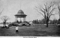 The park, Wakefield, Mass.
 Postcard shows a view of the bandstand on the Common, built in 1885 at a cost of $2,500 as a replacement for an earlier wooden bandstand. The new bandstand was also known as the Pagoda and the Music Pavilion.
-
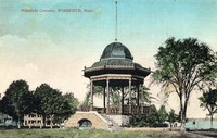
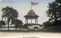
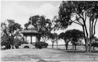
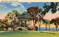 Band stand, Wakefield, Mass.
 Postcard shows a view of the bandstand on the Common, built in 1885 at a cost of $2,500 as a replacement for an earlier wooden bandstand. The new bandstand was also known as the Pagoda and the Music Pavilion.
-
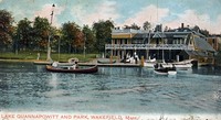
 West shore of Lake Quannapowitt, Wakefield, Mass.
 Postcard shows a view of the west shore of Lake Quannapowitt.
-
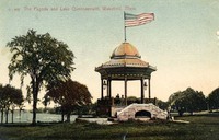 The pagoda and Lake Quannapowitt, Wakefield, Mass.
 Postcard shows a view of the bandstand on the Common, built in 1885 at a cost of $2,500 as a replacement for an earlier wooden bandstand. The new band stand was also known as the Pagoda and the Music Pavilion.
-
 Lake Quannapowitt from Church Street, Wakefield, Mass.
 Postcard shows a view of Lake Quannapowitt from Church Street on the southern shore.
-
 Band stand, Wakefield, Mass.
 Postcard shows a view of the bandstand on the Common, built in 1885 at a cost of $2,500 as a replacement for an earlier wooden bandstand. The new bandstand was also known as the Pagoda and the Music Pavilion.
-
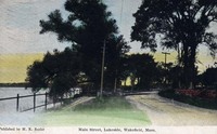 Main Street, lakeside, Wakefield, Mass.
 Postcard shows a view of the lakeside on the eastern shore of Lake Quannapowitt.
-
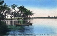
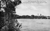 Lake Quannapowitt, Wiley's boat house, Congregational and Baptist churches, Wakefield, Mass.
 Postcard shows a view from the eastern shore of Lake Quannapowitt toward the Common.
-
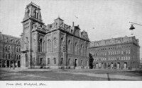 Town Hall, Wakefield, Mass.
-
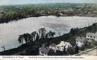 North End of Crystal Lake from Hart's Hill Tower, Wakefield, Mass.
 Postcard shows a view over Crystal Lake looking north from the top of Hart's Hill. Main Street is visible in the foreground. On the far shore the Crystal Lake water filtration plant can be seen. At the upper right the buildings of the Harvard Knitting Mills complex are visible.
-
 The Rockery, Wakefield, Mass.
 Postcard shows the Rockery on Main Street, looking north toward the Common.
-
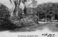
 Baptist Church & Rockery, Wakefield, Mass.
 Postcard depicts a view northwest across Main Street towards the Baptist Church. The Rockery and High School (now Town Hall) are also visible.
-
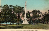 Soldiers and sailors memorial, Wakefield, Mass.
 Postcard shows the Soldiers and Sailors Memorial on the lower common, erected in 1902 to commemorate Wakefield's Civil War casualties.
-
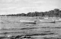
 Lake Quannapowitt and park, Wakefield, Mass.
 Postcard shows Wiley's boat house on the shore of Lake Quannpowitt on Wakefield Common at the end of Spaulding Street.
-
 Spanish war monument and Rockery, Wakefield, Mass.
 Postcard shows the Rockery on Main Street, looking north. The statue known as "The Hiker", by Theo Alice Ruggles Kitson, was dedicated on October 12, 1926 in honor of Wakefield citizens who took part in the Spanish-American War.
-
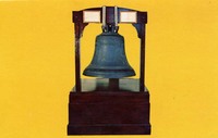 [Paul Revere bell]
 Postcard shows the large "Paul Revere bell", formerly on display at the Lucius Beebe Memorial Library. The bell is famous in town because it was made by the firm of Paul Revere. The work was probably done by his son, Joseph, but the bell is considered an original Revere bell because it was cast during his lifetime. The bell, weighing "about eight hundred and fifty weight", was purchased in 1815 by the town of South Reading for the parish for $350. The bell was hung in steeple of the First Parish Congregational Meeting House. In 1859 it was moved to the cupola of the Town's meeting hall on Church Street. The town hall was moved in 1871 to the corner of Main and Salem Streets and the bell moved with it. In 1888 is was moved to the new High School, what is now the William Lee Memorial Town Hall (Lafayette Building). In 1930 the bell was relocated to the lower lobby of Beebe Library, and in 1973 was brought up to the main floor lobby in the historic part of the building. The bell was transferred to the Wakefield Savings Bank during the Library's renovation and reconstruction in 1997. Later, it was moved to the lobby of the Galvin Middle School, where it remains today.
-
 Rosson's Grove, Wakefield, Mass.
 Postcard shows Rosson's Grove, located at the northern end of Lake Quannapowitt.
-
 Interior view of St. Joseph's church, Wakefield, Mass.
 Postcard shows the interior of St. Joseph's Church at the corner of Albion and Tuttle Streets. The building was destroyed by fire on March 24, 1977.
-
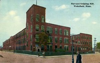
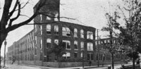 Harvard Knitting Mill, Wakefield, Mass.
 Postcard depicts the Harvard Knitting Mill complex looking south from the corner of Albion and Foundry Streets.
-
 Crystal Lake and Wakefield from Hart's Hill, Wakefield, Mass.
 Postcard shows a view of Crystal Lake and Wakefield looking northwest from the top of Hart's Hill.
-
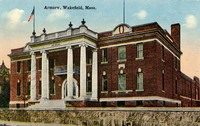
 State armory, Wakefield, Massachusetts
 Postcard shows the Massachusetts State Armory on Main Street at the corner of Armory Street. The building was dedicated on January 15, 1913. In 1975 the town of Wakefield purchased the armory from the state for one dollar. It is now known as the Americal Civic Center and operated by the Americal Civic Center Association.
-
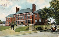
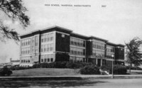 High School, Wakefield, Massachusetts
 Postcard shows a view of Wakefield High School on Main Street at the location of the current Galvin Middle School parking lot. The building was opened in 1923 and was later known as the Atwell building in honor of Superintendent of Schools Willard B. Atwell. It was destroyed by fire on December 12, 1971.
-
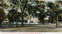
 Lake Quannapowitt, Wakefield, Mass.
 Postcard shows a view of pleasure boats on Lake Quannapowitt, looking north up Main Street from the Common.
-
 Floral Way, Lake Quannapowitt, Wakefield, Mass.
 Postcard shows a view of the Floral Way, an arbored walkway roughly 800 feet long on the south shore of Lake Quannapowitt between the Old Burying Ground and the Hartshorne House. The Floral Way was planted in 1949, mostly with flowering crabtrees, as a living memorial to the town's servicemen and women of all wars.
-
 Harvard Knitting Mill, Wakefield, Mass.
 Postcard depicts the Harvard Knitting Mill complex looking south from the corner of Albion and Foundry Streets.
-
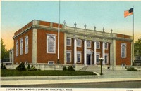
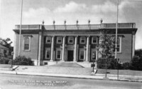 Lucius Beebe Memorial Library, Wakefield, Mass.
 Postcard shows the Lucius Beebe Memorial Library after opening in 1923.
-
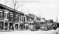 Wakefield Square, Wakefield, Mass.
 Postcard shows the west side of Wakefield Square looking north up Main Street from Richardson Avenue to the Baptist Church. Electric streetcars, which were discontinued in the early 1930s, are visible.
-
 Armory, Wakefield, Mass.
 Postcard shows the Massachusetts State Armory on Main Street at the corner of Armory Street. The building was dedicated on January 15, 1913. In 1975 the town of Wakefield purchased the armory from the state for one dollar. It is now known as the Americal Civic Center and operated by the Americal Civic Center Association.
-
 Lake Quannapowitt and lakeside, Wakefield, Mass.
 Postcard shows a view of Lake Quannapowitt, and the upper common, including the bandstand, looking north from the corner of Main and Pearl Streets.
-
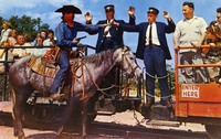 Great train robbery at Pleasure Island
 "On every trip of the Pleasure Island and Western Railroad, attempts are made by armed bandits to board the train to rob passengers and the conductor. They never succeed because the trusty sheriff riding on the train guns them down. (At Pleasure Island, Wakefield, Mass., on Route 128, Exit 21-A, just 14 miles North of Boston" -- Text from back of postcard.
-
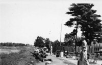
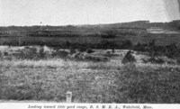 Looking toward 1000 yard range B.S.M.R.A., Wakefield, Mass.
 Postcard shows 1000 yard rifle range at Camp Plunkett, home of the Bay State Rifle Association. The Camp was purchased from them in 1926 by the Commonwealth of Massachusetts, and the name changed to Camp Curtis Guild. It is now home to the Massachusetts National Guard.
-
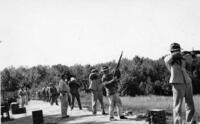
 Camp Curtis Guild
 Postcard shows rifle practice at Camp Curtis Guild, formerly Camp Plunkett. The Camp was purchased from the Bay State Rifle Association in 1926 by the Commonwealth of Massachusetts. It is now home to the Massachusetts National Guard.
-
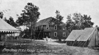
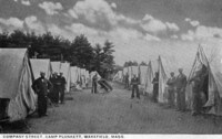 Company Street Camp Plunkett, Wakefield, Mass.
 Postcard shows rifle practice at Camp Curtis Guild, formerly Camp Plunkett. The Camp was purchased from the Bay State Rifle Association in 1926 by the Commonwealth of Massachusetts. It is now home to the Massachusetts National Guard.
-
 Camp Curtis Guild
 Postcard shows rifle practice at Camp Curtis Guild, formerly Camp Plunkett. The Camp was purchased from the Bay State Rifle Association in 1926 by the Commonwealth of Massachusetts. It is now home to the Massachusetts National Guard.
-
 Camp Curtis Guild
 Postcard shows rifle practice at Camp Curtis Guild, formerly Camp Plunkett. The Camp was purchased from the Bay State Rifle Association in 1926 by the Commonwealth of Massachusetts. It is now home to the Massachusetts National Guard.
-
 Camp Curtis Guild
 Postcard shows rifle practice at Camp Curtis Guild, formerly Camp Plunkett. The Camp was purchased from the Bay State Rifle Association in 1926 by the Commonwealth of Massachusetts. It is now home to the Massachusetts National Guard.
-
 Beebe Public Library
 Postcard shows the Lucius Beebe Memorial Library during construction. the new library opened in 1922.
-
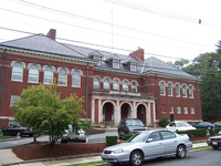
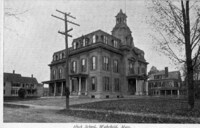 High School, Wakefield, Mass.
 Postcard shows the High School on Wakefield Common at Lafayette Street. Built in 1871, the building was used for school purposes until 1937, when it was remodeled as part of a WPA project for municipal offices. The building, also known as the Lafayette building, is now Wakefield's Town Hall.
-
 Lincoln School, Wakefield, Mass.
 Postcard shows the Lincoln School at the corner of Crescent and Otis Streets. The school was built in 1892 and is now used for elderly housing.
-
 St. Florence's Roman Catholic Church, Butler Avenue, Wakefield, Mass.
 Postcard shows St. Florence's Church on Butler Avenue. The building was completed in 1960.
-
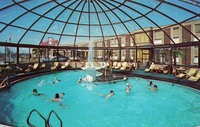
 Lord Wakefield Motor Hotel
 "Lord Wakefield Motor Hotel, At Exit 35, Route 128, Wakefield, Mass., Tel. 617-245-6100. Colonial decorated lakeview dining room, coffee shop, and new Cypress Cove cocktail lounge augment the 92 fully carpeted, air-conditioned bedrooms. Spacious parking and a crystal clear swimming pool add to your pleasure at this modern AAA recommended hostelry." - Text from back of postcard.
-
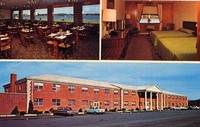
 Colonial Hilton Inn
 "Colonial Hilton Inn, Exit 31 and 32, Rte. 128, Wakefield, Massachusetts, Tel.: 617-245-9300. New England's most spectacular motor inn featuring 180 luxurious rooms and suites. Year 'round glass enclosed pool, health club, 18 hole golf course, cocktail lounge, coffee shop, banquet and meeting rooms. Colonial's Famous Restaurant and Cocktail Lounges with dancing and entertainment. About 20 minutes to downtown Boston and airport." - text from back of postcard.
-
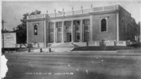
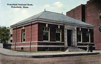 Wakefield National Bank, Wakefield, Mass.
 Postcard shows the Wakefield National Bank building, at the corner of Main and Chestnut Streets. The location is now occupied by the Wakefield Savings Bank.
-
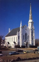
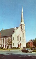 First Baptist Church, Main Street, Wakefield, Mass.
 Postcard shows the First Baptist Church on Main Street. The Church is the third building on the site, and was dedicated on December 11, 1872.
-
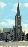
 St. Joseph's Roman Catholic Church, Albion Street, Wakefield, Mass.
 Postcard shows St. Joseph's Church at the corner of Albion and Tuttle Streets. The building was destroyed by fire on March 24, 1977.
-
 Congregational Church, Wakefield, Mass.
 Postcard shows the Congregational Church on the west side of Wakefield Common. The granite church is the fifth church on the site, and was dedicated on February 1, 1912.
-
 Wakefield Common overlooking Lake Quannpowitt, Wakefield, Mass.
 Postcard shows Wakefield Common and the bandstand looking north from Church Street toward Lake Quannapowitt.
-
 Lucius Beebe Memorial Library, Wakefield, Mass.
 Postcard shows the Lucius Beebe Memorial Library after opening in 1923.
-
 Bay State M.R.A. Range, Wakefield, Mass.
 Postcard shows Camp Plunkett, home of the Bay State Rifle Association. The Camp was purchased from them in 1926 by the Commonwealth of Massachusetts, and the name changed to Camp Curtis Guild. It is now home to the Massachusetts National Guard.
-
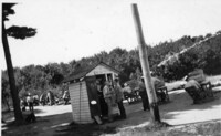
 Entrance to range, Wakefield, Mass.
 Postcard shows the entrance to Camp Plunkett, home of the Bay State Rifle Association. The Camp was purchased from them in 1926 by the Commonwealth of Massachusetts, and the name changed to Camp Curtis Guild. It is now home to the Massachusetts National Guard.
-
 Gold Pan Gulch at Pleasure Island
 "A rustic section at Pleasure Island traces the western movement of early New Englanders. Gun fights are frequent. Stage coaches, covered wagons, buckboards, surreys and a live steam railroad carry visitors into the romantic West. Diamond Lil's Saloon (soft drinks only), the Chisholm Trail, a gold mining operation for guests, and even a newspaper office are popular attractions. The multi-million dollar Park is in Wakefield, Mass., outside Boston, on Route 128, Exit 21A." -- Text from back of postcard.
-
 Authentic country store at Pleasure Island
 "Breck's old country store charms thousands of visitors yearly-with its incredible collection of merchandise from an age long lost. Even a cracker barrel and checker board are available to youngsters. Unusual new gift and souvenir items are sold in the shop on the corner. The big Park covers 100 acres in Wakefield, Mass., on Route 128, Exit 21A, just outside Boston" -- Text from back of postcard.
-
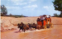 Fording the stream at Pleasure Island
 "The Goldpan Gulch Stage Coach line in Pleasure Island, big new family recreation center in Wakefield, Mass., takes guests thru typical western badlands and splashes through broad streams, on the run for the Stage Depot. The authentic old-time stage coaches accommodate up to 20 children and adults." -- Text from back of postcard.
-
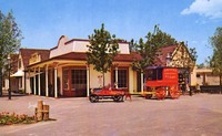
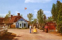 Colonial settlers at Pleasure Island
 "A boy and girl of colonial days stand along Clipper cove, the main street in charming Pleasure Island, the $4,000,000 family fun center in Wakefield, Mass., on Route 128, Exit 21A. The street is an authentic waterfront village as it might have looked a hundred years ago. Note the handspun chocolate shop and historic popcorn wagon." -- Text from back of postcard.
-
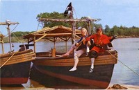 Exciting pirate ride at Pleasure Island
 "Pirates in costume welcome visitors in the authentic thatched-topped boats that sail regularly for Pirate's Cove at Pleasure Island in Wakefield, Mass., on Route 128, Exit 21A, just outside Boston. The popular vessels carry landlubbers to a realistic pirate's hideaway - complete with tree house, animals, lookout towers, and wrecked ships." -- Text from back of postcard.
-
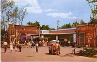
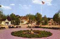 Entrance to fun at Pleasure Island
 "View from the front gate of Pleasure Island, in Wakefield, Mass., shows the Plaza in which thousands of talented free entertainers appear annually. Beyond the Plaza is the main street of Clipper Cove, a quaint attraction in the multi-million dollar family recreation center, on Route 128, Exit 21A." -- Text from back of postcard.
-
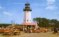 Hawkes Point light house at Pleasure Island
 "Dramatic memories of the men who went down to the sea in ships are recalled by the light house in Clipper Cove, at Pleasure Island, in Wakefield, Mass. The seaman's guide is a focal point in the authentic multi-million dollar reproduction of an early New England waterfront village. The Park is spread across almost a hundred acres on Route 128, Exit 21A, just outside Boston." -- Text from back of postcard.
-
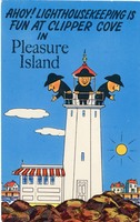 Clipper Cove light house
 "Ahoy! Light housekeeping is fun at Clipper Cove in Pleasure Island" -- from front of postcard
-
 Lucius Beebe Memorial Library, Wakefield, Mass., Children's Room
 Postcard shows the children's room, or south reading room, of the Lucius Beebe Memorial Library after opening in 1923.
-
 House at 142 Main Street, Wakefield, Mass.
 Photos show the house located at 142 Main Street in Beebe Cove on the eastern shore of Lake Quannapowitt. Built in 1810 by noted architect Samuel McIntire of Salem, the Federal style house has several later alterations, including a cupola added between 1858 and 1865. The house was originally the home of the family of Lucius Beebe, and was known as the Beebe Estate or Beebe Farm. It was said to have had one of New England's first indoor bathrooms, with a bathtub "of monstrous proportions". The site was also once the location of the Derby-Beebe Summer House, a small elegant outbuilding also designed by Samuel McIntire. The summerhouse was later moved to Salem, Massachusetts, and is now owned by the Peabody Essex Museum.
-
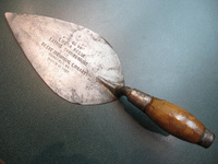 Trowel from the cornerstone-laying ceremony of the Lucius Beebe Memorial Library, Wakefield, Mass.
 Photos show views of the trowel used at the cornerstone-laying ceremony of the Lucius Beebe Memorial Library on March 17, 1922. The artifact was presented by Damien Hurlburt to Library Director Sharon Gilley in July 2009. The trowel was used by Lucia Beebe at the 1922 cornerstone-laying ceremony inaugurating the construction of the new library building, funded in large part by a donation from Junius Beebe, son of Lucius Beebe. Hurlburt found the trowel while cleaning out the basement of his home at 26 Daniel Road. The inscription on the trowel reads, 'USED BY LUCIA BEEBE LAYING CORNERSTONE OF LUCIUS BEEBE MEMORIAL LIBRARY WAKEFIELD MASS. MARCH 17, 1922'. Lucia Beebe was the niece of Lucius Beebe (for whom the library is named) and the sister of Lucius Morris Beebe, who was famous for his high style, society journalism and interest in railroading.
-
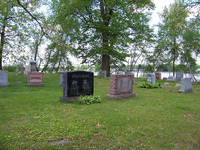
 Yale family plot, Lakeside Cemetery, Wakefield, Mass.
 Photos show views of the Yale family plot in Lakeside Cemetery on North Avenue. The plot is located east of White Ash Avenue between Spruce Avenue and Magnolia Path in the northeast corner of the cemetery.
-
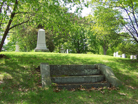
 Grave of William R. and Gertude M. Spaulding, Lakeside Cemetery, Wakefield, Mass.
 Photos show views of the Spaulding gravestone in Lakeside Cemetery on North Avenue. The plot is located on the southern side of the point at the extreme eastern end of the cemetery.
-
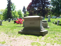 Grave of Elizabeth Boit, Lakeside Cemetery, Wakefield, Mass.
 Photos show views of the gravestone of Elizabeth Boit in Lakeside Cemetery on North Avenue. The plot is located near "Rainbow Path" at the northern end of the cemetery.
-
 Bayrd family plot, Lakeside Cemetery, Wakefield, Mass.
 Photos show views of the Bayrd family plot in Lakeside Cemetery on North Avenue. The plot is located at the corner of Chestnut Avenue and Catalpa Avenue near the center of the cemetery.
-
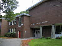 The Robert V. Yeuell School at 0 Crystal Street, Wakefield, Mass.
 Photos show the Robert V. Yeuell School at 0 Crystal Street on the east side of the street in the Greenwood section of Wakefield. The brick elementary school was built in the 1960s in response to overcrowding at the Greenwood School as a result of the Baby Boom. The school was named for Captain Robert V. Yeuell of the 224th Field Artillery Battalion, a Wakefield native who was killed in World War II. No longer used as a public school, in 2008 the Yeuell School is home to the SEEM Collaborative, a nonprofit organization that provides educational services to students with severe disabilities.
-
 West Ward School at 39 Prospect Street, Wakefield, Mass.
 Photos show views of the West Ward School located at 39 Prospect Street on the north side of the street between Goodwin and Nichols Streets. The school was built in 1847 and is thought to be the oldest two-room schoolhouse in Massachusetts that was in continuous use during its 147 years of operation. The school was eventually forced to close when the roof collapsed in 1994 and was turned over from the School Department to the Board of Selectmen. In 1998 the West Ward School Association was awarded permission to restore the building to its original use as a 19th century schoolhouse. The organization aims to make the building a "living history schoolhouse," giving children the opportunity to experience a classroom from the mid to late 19th century.
-
 H. M. Warren School at 30 Converse Street, Wakefield, Mass.
 Photos show views of the H. M. Warren School located at 30 Converse Street on the south side of the street at the corner of Jordan Avenue. The Renaissance Revival style brick structure was built around 1896 and named after Major Horace M. Warren, a local Civil War soldier. The school was closed in 1981, and later used in the 1990s by the local cable television station. The building was then renovated for use as the town's senior center, and opened on June 23, 2002.
-
 Wakefield Park stone entrance gate, Wakefield, Mass.
 Photos show the stone gates located at the intersection of Chestnut Street and Park Avenue at the entrance to the Wakefield Park neighborhood, the development of which began in 1886. The area was promoted as having a healthful and beautiful environment, with elegant homes and building restrictions.
-
 Wakefield Upper Depot at 27-29 Tuttle Street, Wakefield, Mass.
 Photos show views of the Wakefield Upper Depot train station located at 27-29 Tuttle Street on the east side of the street. The railroad tracks and North Avenue lie to the east of the building. The Victorian station is made of brick and was built in 1889. After being brick red for many years, it was repainted in historic colors in the early 2000s. The building's decorative chimney pots are particularly noteworthy. The Haverhill Line commuter rail to Boston still stops here at Wakefield Station, but the building itself is used for commerical offices.
-
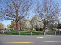 Upper Common, Wakefield, Mass.
 Photos show views of the Upper Common in Wakefield. The Common is divided into two sections by Church Street, which runs east-west. The triangular portion south of Church Street, and bounded by Main and Common Streets, is known as the Upper Common, perhaps because of its slightly higher elevation than that of the Lower Common. It is approximately 2. 5 acres in area. It is more formal than the Lower Common, and has paved paths, flowering trees, benches, Victorian style lampposts, granite and iron fences, and several war memorials, most notably the Soldiers and Sailors Memorial for the Civil War.
-
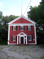
 Unitarian Universalist Church at 326 Main Street, Wakefield, Mass.
 Photos show views of the Unitarian Universalist Church located at 326 Main Street on the east side of the street opposite the Post Office. The church was originally built in 1839 in the Greek Revival style as a temple with a portico on columns facing Main Street. In 1859 the building was substantially altered: it was raised one story, the portico was removed, and a steeple was added. The new version of the building is Italianate in style and has wooden clapboards which on the lower floor are intended to resemble stone. The main entrance on the west end is obscured by a large linden tree in the middle of the front walkway, from which the church's Linden Tree Coffeehouse takes its name. The spire of the church was removed for safety and structural reasons on Tuesday, October 7, 2008.